All trips
National park: Haleakalā, HI

Haleakalā: 2 Days at the Summit, the Crater Rim and Upcountry Maui

Cinder desert, silverswords and a slow-paced pair of days from a Kula base
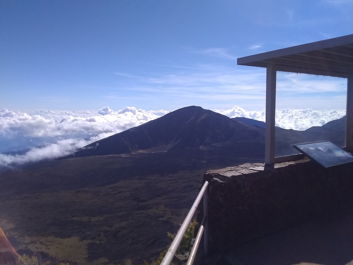
A small shelter looks over a green volcanic valley at Leleiwi Overlook.
Photo: NPS Photo / Mark Kuaola Raymond
Length
2 days
Difficulty
Moderate
Best months
Apr–Jun, Sep–Oct
Budget
$$

Two relaxed days in Haleakalā's summit district, staying in Upcountry Kula: birds at Hosmer Grove, the Sliding Sands overlook, the 10,023-foot summit, and the Halemauʻu Trail to a crater-edge viewpoint. Kīpahulu is covered as a separate extension.

  • Hosmer Grove birding loop
  • Sliding Sands Trail first overlook at 9,700 ft
  • Puʻuʻulaʻula, Maui's highest point at 10,023 ft
  • Halemauʻu Trail crater-edge viewpoint and Rainbow Bridge area
  • Leleiwi Overlook

The story

Haleakalā is two parks in one, and honesty about that is the key to enjoying it. The summit district is a high cinder desert and cloud-belt shrubland an hour or so above Upcountry Maui; Kīpahulu is a wet coastal valley on the far side of the mountain, around four hours away via the Hāna Highway. This two-day plan commits to the summit district and rests properly in between.

Day one eases in: the bird-filled Hosmer Grove loop, a short slide down the Sliding Sands Trail to the first overlook, the 10,023-foot summit, and a late lunch back in Kula. Day two is the real hike, the Halemauʻu Trail to the crater-edge viewpoint, followed by Leleiwi Overlook and a long lunch in Haliʻimaile with the afternoon left open.

Sunrise is the famous draw, but it needs a reservation and a pre-dawn start, so it is offered as a swap rather than built in. Kīpahulu's Pīpīwai Trail is described in the options for anyone who can add a Hāna-area night.

Day by day

Day 1 · 5 stops

Cloud forest, Sliding Sands and the summit

A gentle summit day: a bird loop, one short but high-altitude descent, the top of Maui, then lunch and a long rest in Kula.

Must do
Hike8:30 AM · 45 min

Hosmer Grove Loop

Start in the cloud belt just past the entrance gate, where the loop passes planted conifers, eucalyptus and native shrubland, and a viewing bench for forest birds. Native forest birds frequent this area. It is a gentle 0.54-mile loop just below 7,000 feet, a good way to ease into elevation before the summit.

Photo: NPS Photo
Distance
0.54 mi
Elevation gain
50 ft
Route
Loop
Difficulty
Easy
Dogs allowed
No
Trailhead
Hosmer Grove, end of the Hosmer Grove road
Hosmer Grove Trailhead
30,000 Haleakalā Hwy, Kula, HI 96790
Hours: Open 24 hours; the summit district requires a reservation for entry from 3 am to 7 am.
Season: Open year-round.
Sources (2)
Must do
Hike10:30 AM · 1 h 30 min

Keoneheʻeheʻe (Sliding Sands) Trail to the first overlook

Park at Haleakalā Visitor Center (open sunrise to noon) and take the short sandy descent to the first overlook for a close look at the cinder cones. This is the day's one effort: 0.5 mile round trip, but at 9,700 feet the climb back feels like double. Add the 0.4-mile Pā Kaʻoao loop beside the visitor center for rock-wall shelters and crater views, then rest on the bench.

Photo: NPS Photo
Distance
0.5 mi
Elevation gain
50 ft
Route
Out and back
Difficulty
Moderate
Dogs allowed
No
Trailhead
Keoneheʻeheʻe Trailhead, corner of the Haleakalā Visitor Center parking lot
Keoneheʻeheʻe (Sliding Sands) Trailhead at Haleakalā Visitor Center
30,000 Haleakalā Hwy, Kula, HI 96790
Hours: Trail open daily; visitor center open daily from sunrise to noon, subject to staff availability.
Season: Open year-round; weather changes quickly.
Sources (3)
Must do
Viewpoint12:15 PM · 20 min

Puʻuʻulaʻula Overlook (summit, 10,023 ft)

A short drive up the road is the highest point on Maui, with a sheltered viewing deck that looks across the crater and, on clear days, to neighboring islands. Expect wind and cold even when the coast is warm; a quick 15-20 minutes is plenty before you head down for lunch.

Photo: NPS Photo
Time
15-20 minutes
Best time
Late morning, before afternoon clouds build; clouds can arrive at any time
Fee
Free
Puʻuʻulaʻula (Red Hill) Overlook, summit of Haleakalā
30,000 Haleakalā Hwy, Kula, HI 96790
Hours: Open daily; summit district entry from 3 am to 7 am requires a sunrise reservation.
Season: Open year-round.
Sources (2)
Eat1:45 PM · 1 h

Lunch at Kula Bistro

Relaxed Upcountry lunch a short way past your lodge, about an hour down the mountain from the summit. Lunch and dinner service runs 11 am to 8 pm daily. They do not take reservations, so walk in.

Meal
Lunch
Kula Bistro
4566 Lower Kula Road, Kula, HI 96790
Hours: Breakfast 7:30-10:30 am daily except Monday and Tuesday; lunch and dinner 11 am-8 pm daily; no reservations.
Season: Year-round.
Sources (1)
Stay3:00 PM

Rest and settle in at Kula Lodge

Kula Lodge sits on Haleakalā Highway at Route 377, which is the road to the park, and Kula has the closest hotels and bed-and-breakfasts to the summit district (about 30 minutes by road to Hosmer Grove). The lodge offers cottage-style lodges; spend the afternoon resting, because tomorrow's hike starts around 8:30. Rates are not published on the lodge site; call or email for current rates.

Type
Lodge
Location
Outside the park
Kula Lodge
15200 Haleakalā Highway (Route 377), Kula, HI 96790
Hours: Lodging reservations by phone/email; marketplace daily 7 am-7 pm.
Season: Open year-round.
Sources (2)
Day 2 · 3 stops

Halemauʻu Trail and a slow lunch

One real hike in the morning, a short overlook stop on the way down, then a long lunch in Haliʻimaile and a free afternoon.

Must do
Hike8:30 AM · 2 h

Halemauʻu Trail to the crater-edge viewpoint

The day's one real hike runs along a ridge through native shrubland to a viewpoint where the ground falls away into the Koʻolau Gap on one side and the crater on the other; the natural land bridge known as Rainbow Bridge is about a quarter mile beyond. The trail is rocky and the return is uphill at about 8,000 feet, so take it slowly, carry water and rain layers, and watch for nēnē in the parking lot. A relaxed morning start leaves the rest of the day free.

Photo: NPS Photo
Distance
2.2 mi
Elevation gain
400 ft
Route
Out and back
Difficulty
Moderate
Dogs allowed
No
Trailhead
Halemauʻu Trailhead (pit toilets, no water)
Halemauʻu Trailhead
30,000 Haleakalā Hwy, Kula, HI 96790
Hours: Open daily.
Season: Open year-round; trail is rocky and can be slick after rain.
Sources (2)
Must do
Viewpoint11:00 AM · 40 min

Leleiwi Overlook

On the way back down, stop at a short, rocky trail to a viewpoint over the crater and the lush meadows below. It is 0.3 mile round trip with a few uneven steps, so it makes an easy final stretch of the legs. Clouds drifting through the valley change the view minute to minute.

Photo: NPS Photo / Mark Kuaola Raymond
Distance
0.3 mi
Time
30-60 minutes; round-trip distance
Best time
Late morning
Fee
Free
Route type
out_and_back
Elevation gain ft
100
Leleiwi Overlook
30,000 Haleakalā Hwy, Kula, HI 96790
Hours: Open daily.
Season: Open year-round.
Sources (2)
Eat1:00 PM · 1 h 15 min

Lunch at Haliʻimaile General Store

Finish with a sit-down lunch in Haliʻimaile, in the Upcountry foothills about an hour below the overlook. Lunch runs 11 am to 2:30 pm daily and reservations are strongly recommended. After lunch the day is yours: nothing is scheduled so that you can recover from the altitude.

Meal
Lunch
Cuisine
Regional Hawaiian
Reservation needed
Yes
Haliʻimaile General Store
900 Haliʻimaile Road, Makawao, HI 96768
Hours: Daily 11 am-8 pm; lunch 11 am-2:30 pm, dinner from 4:30 pm. Reservations strongly recommended.
Season: Year-round.
Sources (1)

Where to stay

Stay

Hosmer Grove Campground (in the park)

Drive-up tent camping in the cloud belt just below 7,000 feet at the summit district, reservable online. Expect rain and cold nights near freezing. Recreation.gov reservation required, $20 per night, up to 3 consecutive nights. Water may be off (see current conditions); bring your own.

Type
Campground
Location
Inside the park
Price per night
From $20 (as of 2026-10-14)
Hosmer Grove Campground
30,000 Haleakalā Hwy, Kula, HI 96790
Hours: Open all day, year-round.
Season: Open year-round.
Sources (2)
Stay

Kīpahulu Campground (for the Kīpahulu extension)

Oceanside drive-up campground a short walk from Kūloa Point and the visitor center. It puts you at the Pīpīwai trailhead for early starts. Often wet and far from amenities; $20 per night, up to 3 consecutive nights, reservations on a 30-day rolling window; no water at the campground (water station at the visitor center).

Type
Campground
Location
Inside the park
Price per night
From $20 (as of 2026-10-14)
Kīpahulu Campground
Mile Marker 41 Hana Highway, Hana, HI 96713
Hours: Check-in 2 pm; check-out by 11 am.
Season: Open year-round.
Sources (2)

More options

Viewpoint

Kalahaku Overlook

Roadside viewpoint at about 9,300 feet with a wide vista over the crater floor and its cinder cones. A quieter alternative to the busiest summit parking lots.

Viewpoint20 min

Kalahaku Overlook

Roadside viewpoint at about 9,300 feet with a wide vista over the crater floor and its cinder cones. A quieter alternative to the busiest summit parking lots.

Photo: NPS Photo
Time
15-20 minutes
Fee
Free
Kalahaku Overlook
30,000 Haleakalā Hwy, Kula, HI 96790
Hours: Open daily.
Season: Open year-round.
Sources (2)
Activity

Sunrise from Haleakalā Visitor Center

For those who want sunrise, the Haleakalā Visitor Center rim is one of four recommended viewpoints. Entering the summit district between 3 am and 7 am requires a sunrise reservation; book on Recreation.gov ahead of time. Dress for freezing wind, allow about an hour to drive from Kula Lodge, and plan a nap afterwards rather than adding other hikes.

Activity5:00 AM · 2 h 30 min

Sunrise from Haleakalā Visitor Center

For those who want sunrise, the Haleakalā Visitor Center rim is one of four recommended viewpoints. Entering the summit district between 3 am and 7 am requires a sunrise reservation; book on Recreation.gov ahead of time. Dress for freezing wind, allow about an hour to drive from Kula Lodge, and plan a nap afterwards rather than adding other hikes.

Photo: NPS Photo
Time
2-4 hours
Best time
Sunrise
Fee
$1
Reservation needed
Yes
Haleakalā Visitor Center
30,000 Haleakalā Hwy, Kula, HI 96790
Hours: Daily, sunrise to 12:00 PM, subject to staff availability.
Season: Open year-round.
Sources (3)
Hike

Pīpīwai Trail to the bamboo forest and Waimoku Falls (Kīpahulu extension)

The district's signature walk climbs past Makahiku Falls overlook (0.5 mi) and through a bamboo grove to the base of 400-foot Waimoku Falls. It is 4 miles round trip with an 800-ft gain on a muddy trail. Kīpahulu lies about four hours' drive from Kahului via the Hāna Highway and is not connected to the summit by road, so treat it as a separate trip with a Hāna-area night, not part of these two days.

Hike4 h

Pīpīwai Trail to the bamboo forest and Waimoku Falls (Kīpahulu extension)

The district's signature walk climbs past Makahiku Falls overlook (0.5 mi) and through a bamboo grove to the base of 400-foot Waimoku Falls. It is 4 miles round trip with an 800-ft gain on a muddy trail. Kīpahulu lies about four hours' drive from Kahului via the Hāna Highway and is not connected to the summit by road, so treat it as a separate trip with a Hāna-area night, not part of these two days.

Photo: NPS
Distance
4 mi
Elevation gain
800 ft
Route
Out and back
Difficulty
Moderate
Dogs allowed
No
Trailhead
Behind Kīpahulu Visitor Center (distance round trip)
Pīpīwai Trail (from Kīpahulu Visitor Center)
Mile Marker 42 Hana Highway, Hana, HI 96713
Hours: Open daily.
Season: Open year-round; muddy after rain and flash floods can occur.
Sources (3)
Viewpoint

Kūloa Point Trail and the Pools of ʻOheʻo (Kīpahulu extension)

A 0.5-mile walk from the Kīpahulu Visitor Center out to the ocean at Kūloa Point, passing a cultural demonstration area and looking up the gulch to the cascades. Entering the pools is not allowed.

Viewpoint1 h

Kūloa Point Trail and the Pools of ʻOheʻo (Kīpahulu extension)

A 0.5-mile walk from the Kīpahulu Visitor Center out to the ocean at Kūloa Point, passing a cultural demonstration area and looking up the gulch to the cascades. Entering the pools is not allowed.

Photo: NPS Photo
Time
0.5 mile total, 80 ft elevation change
Fee
Free
Kūloa Point and the Pools of ʻOheʻo
Mile Marker 42 Hana Highway, Hana, HI 96713
Hours: Open daily.
Season: Open year-round.
Sources (2)

Map of places

  1. Hosmer Grove Trailhead (opens Google Maps in a new tab) Day 1
  2. Keoneheʻeheʻe (Sliding Sands) Trailhead at Haleakalā Visitor Center (opens Google Maps in a new tab) Day 1
  3. Puʻuʻulaʻula (Red Hill) Overlook, summit of Haleakalā (opens Google Maps in a new tab) Day 1
  4. Kula Bistro (opens Google Maps in a new tab) Day 1
  5. Kula Lodge (opens Google Maps in a new tab) Day 1
  6. Halemauʻu Trailhead (opens Google Maps in a new tab) Day 2
  7. Leleiwi Overlook (opens Google Maps in a new tab) Day 2
  8. Haliʻimaile General Store (opens Google Maps in a new tab) Day 2
  9. Kalahaku Overlook (opens Google Maps in a new tab) Option
  10. Haleakalā Visitor Center (opens Google Maps in a new tab) Option
  11. Pīpīwai Trail (from Kīpahulu Visitor Center) (opens Google Maps in a new tab) Option
  12. Kūloa Point and the Pools of ʻOheʻo (opens Google Maps in a new tab) Option
  13. Hosmer Grove Campground (opens Google Maps in a new tab) Option
  14. Kīpahulu Campground (opens Google Maps in a new tab) Option

Good to know

Current conditions (as of 2026-10-14)

  • Sunrise reservation ($1.00 per vehicle) is required to enter the summit district between 3 am and 7 am; book on Recreation.gov. Tickets release 60 days ahead, with some held until 2 days before, released at 7 am HST. A separate park entrance fee applies ($30 per private vehicle, valid 3 days).
  • Summit entrance station: cars can be turned back before sunset when capacity is reached; arrive about 3 hours before sunset.
  • Haleakalā Visitor Center parking is limited and traffic delays are possible because of a water infrastructure project that started January 12, 2026.
  • Planned closures: Haleakalā Visitor Center 2027-02-19 to 2027-05-20 (building improvement project); Headquarters Visitor Center 2027-02-17 to 2027-02-27.
  • Hosmer Grove Campground has no water due to a waterline break; water is at Headquarters Visitor Center.
  • Kula Lodge's restaurant is closed indefinitely after a fire; its food truck (7 am-7 pm) and marketplace are open.

Want live alerts and up-to-date info?

Conditions change fast. Create an account on the DriftKin app to get live park alerts, closures and information for your trip.

Get the DriftKin app

Practical tips

  • Both days fit one park pass; no gas, food or charging in the park, so fill up in Pukalani first.
  • Dress in layers: summit temperatures commonly run 30-65 F with strong wind; bring rain gear, sun protection and water.
  • Altitude: if you get a headache, nausea or dizziness, descend; hiking down means roughly double the time to climb out.
  • Drive carefully for nēnē and other endangered birds on the road.
  • The summit district is roughly 1.5 to 2 hours from Kahului depending on traffic and stops (a more conservative published estimate is 2.5 hours), and Kīpahulu is about 4 hours from Kahului; the two are not connected by road. Kīpahulu is offered as an extension with a Hāna-area overnight, not as part of these two days.
  • Other places to stay: Kula has the closest hotels and bed-and-breakfasts; the Hāna area is nearest to Kīpahulu.

Sources

Good to know: distances and drive times are typical figures without live traffic, and where routes are shown the route data comes from OpenStreetMap contributors. Toll amounts are estimates and change often, so check them in the DriftKin planner or with the toll authority before you plan around them. Opening hours, fees, prices, permits and closures also change, so confirm with the park or business before you go.