All trips
National park: Black Canyon Of The Gunnison, CO

Black Canyon of the Gunnison: 2 Days of Rim Views and the River

Painted Wall, East Portal and Warner Point from a Montrose base
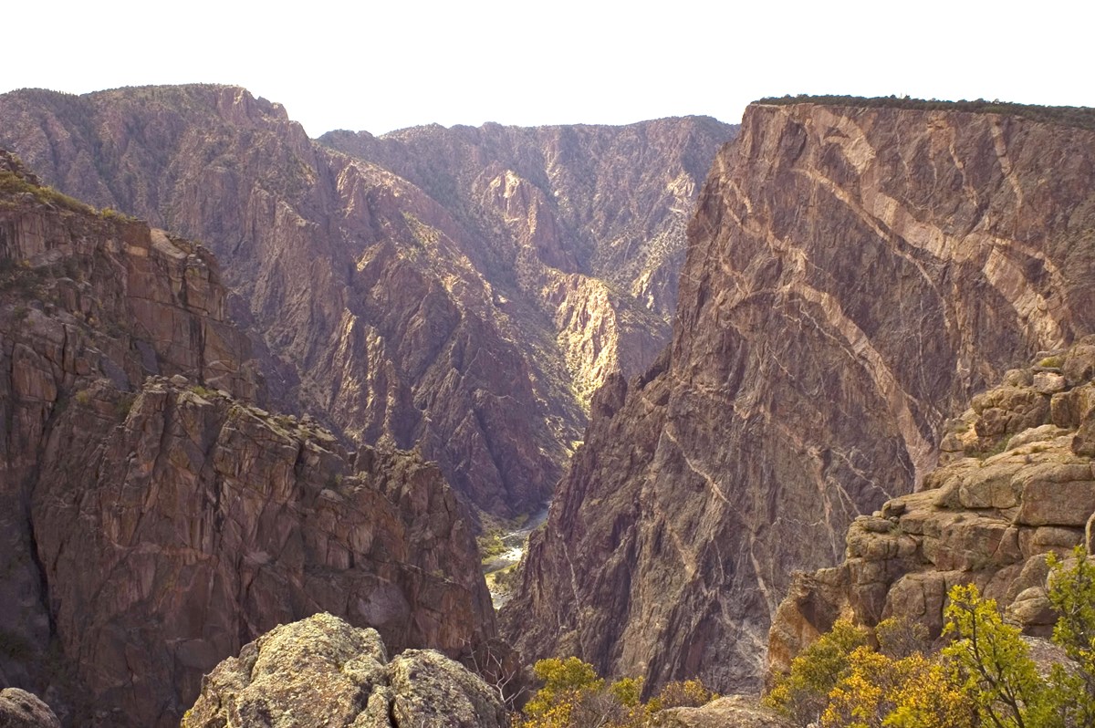
Sunlit canyon walls with pale pegmatite stripes on the Painted Wall and the Gunnison River far below
Photo: NPS Photo
Length
2 days
Difficulty
Moderate
Best months
May–Jun, Sep–Oct

Two paced days at Colorado's deepest, darkest canyon: easy South Rim overlooks on Day 1, then the winding drive to the Gunnison River and one short high-altitude hike on Day 2. Based in Montrose, about 28 minutes from the rim.

  • Painted Wall, a 2,250-ft cliff streaked with pale bands
  • Cedar Point's short rim walk
  • East Portal Road down to the Gunnison River
  • Warner Point Nature Trail with San Juan and West Elk views
  • Relaxed Montrose base with a cafe lunch and dinner

The story

Black Canyon is a place of vertical drama rather than long trails. The Gunnison River has cut a deep, narrow gorge, and the dark, striped walls reward slow looking more than hard hiking. That makes it ideal for two relaxed days based in Montrose, about 28 minutes from the South Rim.

Day 1 is easy and entirely on the rim. You start at the visitor center and Gunnison Point, drive to Painted Wall, Colorado's tallest cliff, and add the short Cedar Point trail, then head back to Montrose for lunch with energy to spare and a restful afternoon.

Day 2 has the single demanding effort. East Portal Road takes you down to the river first, then you climb back out to High Point for the Warner Point Nature Trail, a short but breathless 1.6-mile round trip at about 8,000 ft, finishing at Sunset View before heading to lunch.

The inner-canyon routes to the river are steep, permit-gated and not part of this plan. Bring layers, since the rim sits near 8,000 ft; water and a slow pace matter more than speed.

Day by day

Day 1 · 6 stops

South Rim overlooks and easy walks

Visitor center, Painted Wall and Cedar Point, then lunch and a restful afternoon in Montrose.

Visitor center9:45 AM · 45 min

South Rim Visitor Center and Gunnison Point

Start where the canyon first shows itself. Walk the short path to Gunnison Point for a first look into the gorge, then step into the log-built visitor center for exhibits, maps and trail guides. The center is at about 8,000 ft, so take the first hour slowly and carry water; the park's water supply is seasonal.

Photo: NPS photo
Time
The hotel is about 28 minutes from the visitor center; central Montrose is 14.7 mi and 24 minutes by the local OSM router.
South Rim Visitor Center
9800 Highway 347, Montrose, CO 81401
Hours: Typically 8am-5pm in summer and 9am-4pm in winter; closed Thanksgiving, Christmas and New Year's Day; check current hours
Season: Open year-round
Sources (2)
Must do
Viewpoint10:45 AM · 30 min

Painted Wall Overlook

The headliner. Painted Wall is a 2,250-ft cliff (the tallest in Colorado) streaked with pale pegmatite bands, and this overlook faces it across the gorge with the Gunnison River far below. It is 3.8 miles and about 8 minutes from the visitor center on South Rim Road. Allow time to let your eyes pick out the bands.

Photo: NPS Photo
Time
Short walk from the parking area.
Best time
Morning
Painted Wall Overlook
South Rim Road, Montrose, CO 81401
Season: Typically reachable by car when South Rim Road is open (usually late April to mid-November); check current dates
Sources (2)
Must do
Activity11:25 AM · 35 min

Cedar Point Nature Trail

A 0.2-mile out-and-back stroll, one minute by road from Painted Wall, with guideposts naming the plants along the way and two overlooks at the end. It gives a second, quieter angle on the same walls and the river. It is unpaved and moderately sloped, and leashed dogs are allowed.

Photo: NPS Photo
Distance
0.2 mi
Time
Starts from the Cedar Point Nature Trail parking area off South Rim Drive.
Difficulty
easy
Dogs allowed
Yes
Cedar Point Nature Trail
South Rim Road, Montrose, CO 81401
Season: Typically accessible when South Rim Road is open; check current dates
Sources (1)
Eat12:45 PM · 1 h

Bluecorn Cafe

A relaxed Montrose cafe on Townsend Avenue serving coffee, baked goods, breakfast, brunch and lunch made with local ingredients, with a small mercantile attached. It sits on the way back from the park, so a 12:45 lunch lands after the 32-minute drive from Cedar Point with plenty of time before it closes.

Meal
Lunch
Cuisine
Cafe, breakfast and lunch
Bluecorn Cafe
1842 S Townsend Ave, Montrose, CO 81401
Hours: Daily, 7am-4pm (website)
Sources (1)
Stay

Holiday Inn Express & Suites Montrose - Black Canyon Area

A chain hotel on South Townsend Avenue and the practical base for both days. It offers complimentary full breakfast, an indoor pool and spa, and pet-friendly rooms. The South Rim Visitor Center is about 28 minutes away by car.

Type
Hotel
Location
Outside the park
Holiday Inn Express & Suites Montrose - Black Canyon Area
1391 S Townsend Ave, Montrose, CO 81401
Sources (3)
Eat6:30 PM · 1 h 15 min

Dinner at Camp Robber

A Southwestern-leaning restaurant whose menu spans salads, pasta, steak and seafood, New Mexican dishes and house-made desserts, and which advertises dishes made by hand on site. It is an unhurried way to end a day of rim-walking. The website shows Monday to Saturday hours and none for Sunday, so on a Sunday call 970-240-1590 first; no Sunday dinner alternative could be verified, so move the main meal to lunch at Bluecorn Cafe, open daily until 4pm. Call to confirm hours either way.

Meal
Dinner
Cuisine
Southwestern
Camp Robber
1515 Ogden Rd, Montrose, CO 81401
Hours: Monday-Saturday 11:00am-8:30pm (website; no Sunday hours shown, call to confirm)
Sources (2)
Day 2 · 4 stops

Down to the river, up to Warner Point

East Portal Road from 08:50, the demanding Warner Point trail at 11:00, Sunset View on the way out, and lunch in Montrose.

Must do
Scenic drive8:50 AM · 1 h 30 min

East Portal Road and the Gunnison River

A steep, winding road drops 5.2 miles from the rim to the river, with grades up to 16 percent, where you can walk the riverbank beneath the canyon walls and see the diversion dam and tunnel works. Use low gear on the descent. Vehicles over 22 ft are prohibited. East Portal is within Curecanti National Recreation Area but only reached through this park.

Photo: NPS/C. Roundtree
Time
From the hotel the river at East Portal is about 38 minutes by the local OSM router (18.8 mi from central Montrose, 34 min). Allow 1 to 2 hours there; the climb back to High Point is about 12.7 mi and 30 minutes.
Best time
Morning
East Portal Road
East Portal Road, Montrose, CO 81401
Season: Typically open spring through fall and closed in winter, usually November to April (set by the Bureau of Reclamation); check current dates
Sources (2)
Must do
Hike11:00 AM · 1 h 15 min

Warner Point Nature Trail

The day's one real effort: 0.8 miles one way along the rim from the High Point lot, with shaded benches among mountain mahogany, pinyon and juniper, and big views of the San Juan and West Elk ranges before a final look into the canyon. It is short but at about 8,000 ft the 200-ft elevation change and steep sections feel harder than the number suggests. Allow 75 minutes round trip and carry water.

Photo: NPS/de Anguera
Distance
1.6 mi
Elevation gain
200 ft
Route
Out and back
Difficulty
Moderate
Dogs allowed
No
Trailhead
High Point parking area at the end of South Rim Drive. Distance is round trip (0.8 mi each way). The 200 ft is the trail guide's published elevation change for the trail; no direction is stated. The trail guide rates it Moderate and the trail page says Moderate strenuous. Coordinates are the High Point Overlook place record, adjacent to the trailhead.
Warner Point Trail
High Point, South Rim Road, Montrose, CO 81401
Season: Typically accessible when South Rim Road is open to High Point; check current dates
Sources (2)
Viewpoint12:25 PM · 20 min

Sunset View Overlook

On the way back toward the visitor center, stop at Sunset View, which sits two minutes from High Point and is one of the three accessible overlooks along the drive. It is an easy final stop with short walking; the park suggests it as one of the overlooks to prioritize if time is limited, and it is also one of its stargazing spots after dark.

Photo: NPS Photo
Time
About 0.8 mi and 2 minutes from High Point by road.
Best time
Midday (as scheduled); also a stargazing spot after dark
Sunset View Overlook
South Rim Road, Montrose, CO 81401
Season: Typically reachable when South Rim Road is open; check current dates
Sources (1)
Logistics1:30 PM · 1 h

Lunch in Montrose and departure

From Sunset View the drive back to Montrose takes about 35 to 40 minutes, arriving around 13:25. Bluecorn Cafe (Day 1) is open until 4pm daily if you want a second meal there, and Camp Robber is the dinner option if you stay another evening. Plan to eat on arrival in town.

Time
Sunset View to central Montrose is about 20 mi and 35 minutes by the local OSM router; add a few minutes to the hotel.
Sources (1)

Where to stay

Stay

Stay Wise Inn

A budget motel on East Main Street in Montrose, pet-friendly with complimentary breakfast and wifi, and close to Black Canyon of the Gunnison National Park. The operator's own domain could not be verified, so confirm bookings by phone.

Stay

Stay Wise Inn

A budget motel on East Main Street in Montrose, pet-friendly with complimentary breakfast and wifi, and close to Black Canyon of the Gunnison National Park. The operator's own domain could not be verified, so confirm bookings by phone.

Type
Hotel
Location
Outside the park
Stay Wise Inn
2100 E Main St, Montrose, CO 81401
Sources (1)
Stay

South Rim Campground

The in-park campground, one mile from the South Rim Visitor Center. All sites are booked in advance through Recreation.gov, and the campground is open all year, though only Loop B stays open in winter. Water is typically available only from mid-May to mid-September.

Stay

South Rim Campground

The in-park campground, one mile from the South Rim Visitor Center. All sites are booked in advance through Recreation.gov, and the campground is open all year, though only Loop B stays open in winter. Water is typically available only from mid-May to mid-September.

Type
Campground
Location
Inside the park
South Rim Campground
South Rim, Black Canyon of the Gunnison National Park, Montrose, CO 81401
Hours: Open 24 hours, all year; check-out 11am
Season: Check current loop availability
Sources (1)

More options

Hike

Oak Flat Loop Trail

An alternative for anyone who wants a below-rim walk: a steep descent below the rim through Gambel oak, aspen and Douglas fir, then a climb back. It is steep and narrow in places, so treat it as a second demanding effort and not a companion to Warner Point on the same day. No dogs.

Hike1 h 30 min

Oak Flat Loop Trail

An alternative for anyone who wants a below-rim walk: a steep descent below the rim through Gambel oak, aspen and Douglas fir, then a climb back. It is steep and narrow in places, so treat it as a second demanding effort and not a companion to Warner Point on the same day. No dogs.

Photo: NPS Photo
Distance
1.6 mi
Elevation gain
400 ft
Route
Loop
Difficulty
Strenuous
Dogs allowed
No
Trailhead
South Rim Visitor Center. Distance is the round-trip loop; the trail guide describes it as dropping 400 ft through aspen and Douglas fir, so the return climb is about 400 ft.
Oak Flat Loop Trail
South Rim Visitor Center, 9800 Highway 347, Montrose, CO 81401
Season: Typically open when the trail is clear of snow and ice; check current conditions
Sources (2)
Activity

Rim Rock Trail

A short stroll that is fairly level with some stairs and uneven spots: it follows the rim between the visitor center and the South Rim Campground, with Tomichi Point about halfway. Leashed dogs are allowed except in summer. Walk as far as Tomichi Point and back if you want a quiet half hour.

Activity45 min

Rim Rock Trail

A short stroll that is fairly level with some stairs and uneven spots: it follows the rim between the visitor center and the South Rim Campground, with Tomichi Point about halfway. Leashed dogs are allowed except in summer. Walk as far as Tomichi Point and back if you want a quiet half hour.

Photo: NPS Photo
Distance
0.9 mi
Difficulty
moderate
Dogs allowed
Yes
Rim Rock Trail
South Rim Campground, Loop C entrance, Montrose, CO 81401
Season: Typically open when clear of snow and ice; check current conditions
Sources (2)
Scenic drive

North Rim Road

For a separate day: the gravel North Rim Road reaches six overlooks with nearly vertical walls, and the walls here are almost vertical. It starts about 11 miles southwest of Crawford and is not within a realistic reach of this two-day plan.

Scenic drive2 h 30 min

North Rim Road

For a separate day: the gravel North Rim Road reaches six overlooks with nearly vertical walls, and the walls here are almost vertical. It starts about 11 miles southwest of Crawford and is not within a realistic reach of this two-day plan.

Photo: NPS/Ethan Crump
Time
Allow 2-3 hours for the road and overlooks, plus the drive from Montrose.
North Rim Road
7295 Black Canyon Road, Crawford, CO 81415
Season: Typically open roughly May to mid-November; check current dates
Sources (2)

Map of places

  1. South Rim Visitor Center (opens Google Maps in a new tab) Day 1
  2. Painted Wall Overlook (opens Google Maps in a new tab) Day 1
  3. Cedar Point Nature Trail (opens Google Maps in a new tab) Day 1
  4. East Portal Road (opens Google Maps in a new tab) Day 2
  5. Warner Point Trail (opens Google Maps in a new tab) Day 2
  6. Sunset View Overlook (opens Google Maps in a new tab) Day 2
  7. South Rim Campground (opens Google Maps in a new tab) Option
  8. Oak Flat Loop Trail (opens Google Maps in a new tab) Option
  9. Rim Rock Trail (opens Google Maps in a new tab) Option
  10. North Rim Road (opens Google Maps in a new tab) Option

Good to know

  • Park fee is $30 per private vehicle (7 days), $15 on foot or bicycle; the park is cashless, so bring a card.
  • No food or lodging inside the park; stock up in Montrose. Water in the park is seasonal.
  • Rim elevation is about 8,000 ft. Hydrate, protect against the sun, and pace the Day 2 hike.
  • Pets are allowed on roads, overlooks, Rim Rock, Cedar Point and the North Rim Chasm View trail, but not on Warner Point or Oak Flat.
  • Stay behind rim barriers and never throw rocks; people hike and climb below.
  • The inner-canyon routes require permits and are not part of this trip.

Current conditions (as of 2026-10-22):

  • The park's conditions page (updated 2026-10-13) shows South Rim, North Rim and East Portal roads open.
  • South Rim Visitor Center is on winter hours (9am-4pm) from 2026-10-18; it is closed 2026-11-26 and 2026-12-25.
  • South Rim Road is usually open to vehicles until about mid-November; the North Rim Road typically closes mid-November. East Portal Road is typically closed from November to April, with the date set by the Bureau of Reclamation, so check the conditions page before driving down; East Portal Campground closes 2026-11-10.
  • Water systems are shut off for the winter season (October to April).
  • South Rim Campground currently has limited non-electric sites because of wildfire damage.

Want live alerts and up-to-date info?

Conditions change fast. Create an account on the DriftKin app to get live park alerts, closures and information for your trip.

Get the DriftKin app

Sources

Good to know: distances and drive times are typical figures without live traffic, and where routes are shown the route data comes from OpenStreetMap contributors. Toll amounts are estimates and change often, so check them in the DriftKin planner or with the toll authority before you plan around them. Opening hours, fees, prices, permits and closures also change, so confirm with the park or business before you go.