Canyonlands: 2 Days of Rims, Domes and Sunrise at Mesa Arch
Island in the Sky from a Moab base
- Length
- 2 days
- Difficulty
- Easy
- Best months
- Apr–May, Sep–Oct
- Budget
- $$
Two days on Canyonlands' Island in the Sky mesa: Whale Rock, Upheaval Dome and Grand View Point, then Mesa Arch at sunrise and the Green River Overlook. One Moab hotel, with a Needles swap option.
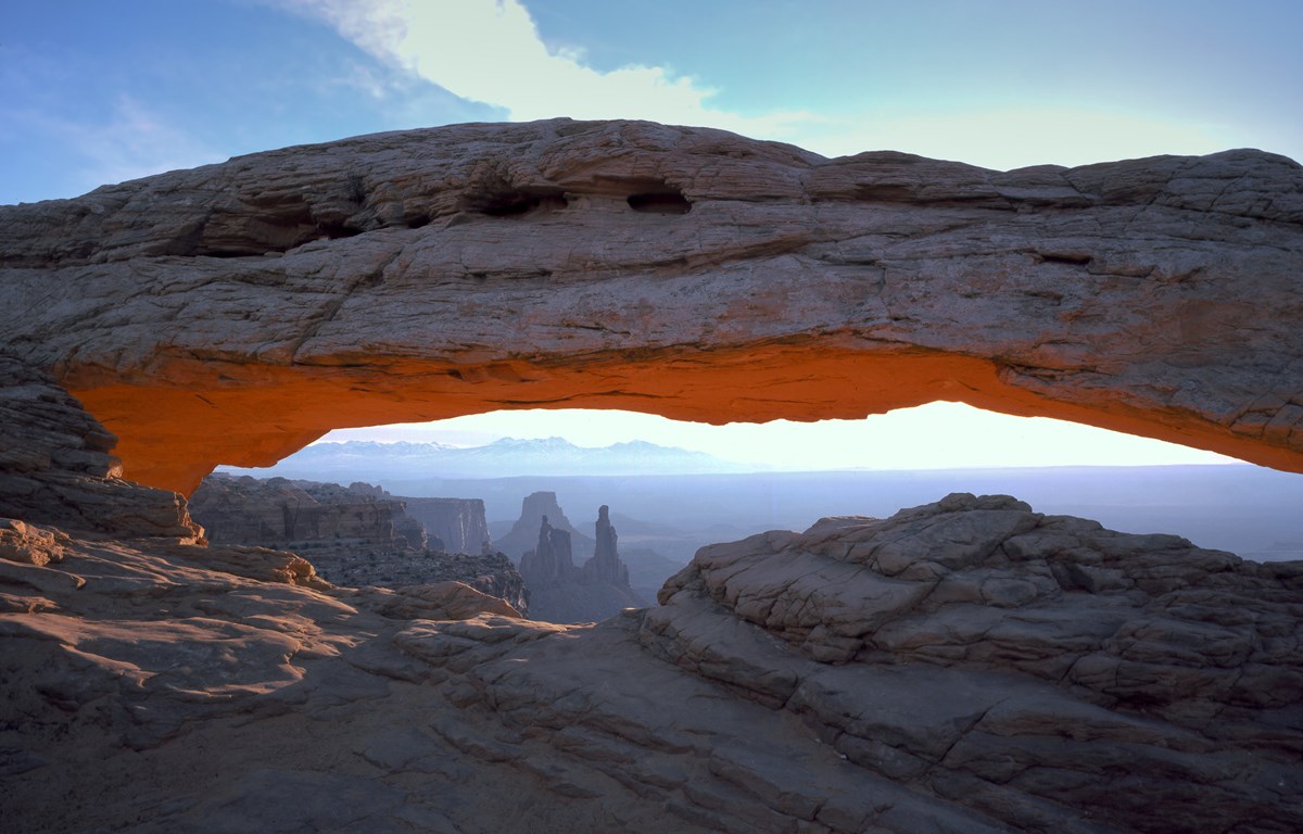
- Sunrise at Mesa Arch
- Steep overlook hike into Upheaval Dome
- Slickrock scramble up Whale Rock
- Rim walk at Grand View Point
- Green River Overlook, a sunset spot per NPS
The story
Island in the Sky is a flat-topped mesa that ends in cliffs, with the White Rim bench and two rivers far below. One paved road runs along it, and every stop here sits on that road or a short spur, about 22 miles down UT 313 from US 191 according to NPS.
Day one (allow a 30-minute buffer for the entrance line) works the mesa from the north end: a slickrock scramble up Whale Rock, the steep overlook walk at Upheaval Dome, a three-mile-wide ring of twisted rock whose origin NPS says geologists still debate, and the rim walk at Grand View Point, the paved road's end. Day two is about light. Mesa Arch at sunrise, then the Green River Overlook, which NPS counts among the best sunset spots on the island, and a look down the Shafer Trail on the way out.
Both nights are at Moab's Aarchway Inn, on the north edge of town and nearest the park turnoff. There is no food or lodging on the mesa, and NPS cautions services are minimal across the park, so pack lunch and water for Day one. The Needles, a separate district far by road, appears only as an optional swap.
Day by day
Whale Rock, Upheaval Dome and Grand View Point
Breakfast in Moab, then two short geology hikes on the north end of the mesa and a long rim walk at the south end.
Breakfast at Jailhouse Cafe
A historic building on Moab's Main Street, billed by the Discover Moab tourism guide as Moab's breakfast place, with chorizo scrambles, Swedish pancakes and eggs Benedict among the highlights it names. The guide gives hours of 7 AM to noon daily and the cafe is not on the mesa, so eat here before the drive; arrive early as the guide notes possible waits.
- Meal
- Breakfast
- Cuisine
- American breakfast
- Reservation needed
- No
Sources (2)
- Discover Moab - Fine Dining to Food Trucks (Jailhouse Cafe) · retrieved 2026-10-06
- OpenStreetMap - Jailhouse Cafe (coordinates) · retrieved 2026-10-06
Whale Rock Trail
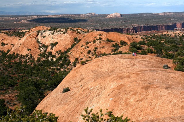
A slickrock climb up the flank of a sandstone dome to a high point with wide views across the mesa. NPS says the trail follows the dome's side, then climbs from its tail to its blowhole, and calls it great for kids who like to scramble. Wear shoes with good traction and stay back from the steep drop-offs. Whale Rock is part of the sandstone ring around Upheaval Dome.
- Distance
- 0.8 mi
- Elevation gain
- 141 ft
- Route
- Out and back
- Difficulty
- Moderate
- Dogs allowed
- No
- Trailhead
- Whale Rock trailhead on Upheaval Dome Road, Island in the Sky
- Distance note
- NPS place page: 0.8 mi round trip, 141 ft elevation change, about 1 hour. The NPS hiking page rounds the change to 100 ft; this plan uses the place-page figure. Round-trip basis.
Sources (3)
- NPS Data API - places (cany) · retrieved 2026-10-06
- NPS - Canyonlands hiking · retrieved 2026-10-06
- NPS - Whale Rock Trail · retrieved 2026-10-06
Upheaval Dome Overlooks Trail
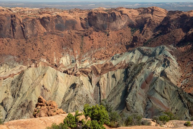
A short, steep climb to a view into Upheaval Dome, a roughly three-mile-wide circle of tilted and folded rock that geologists have not settled on an origin for. NPS describes two competing theories, a collapsed salt dome and a meteorite impact, and puts exhibits at the first overlook. The first overlook is the one to do; the second adds a cairn-marked mile.
- Distance
- 0.6 mi
- Elevation gain
- 115 ft
- Route
- Out and back
- Difficulty
- Moderate
- Trailhead
- End of Upheaval Dome Road, Island in the Sky
- Distance note
- First overlook only: 0.6 mi round trip, 115 ft elevation change, about 1 hour (NPS place page). The NPS hiking page says about 100 ft and 30 minutes; the second overlook is 1.2 mi round trip with 114 ft of change. Round-trip basis.
Sources (4)
- NPS Data API - places (cany) · retrieved 2026-10-06
- NPS - Canyonlands hiking · retrieved 2026-10-06
- NPS - Upheaval Dome Overlooks Trail · retrieved 2026-10-06
- NPS - Upheaval Dome · retrieved 2026-10-06
Grand View Point Overlook and Trail
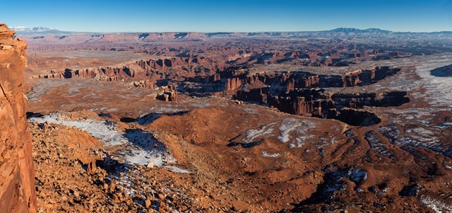
The mesa's southern tip, where the paved road ends at a rim with views over corrugated canyons, the White Rim Road below and, on clear days, features of The Maze and The Needles. A short paved sidewalk leads to the main overlook, then NPS describes an additional mile of rim walking to a second viewpoint. Rangers often give geology talks here spring through fall.
- Distance
- 1.8 mi
- Elevation gain
- 73 ft
- Route
- Out and back
- Difficulty
- Easy
- Dogs allowed
- No
- Trailhead
- Grand View Point parking area at the end of the Island in the Sky road
- Distance note
- NPS: 1.8 mi round trip, 73 ft elevation change, about 1.5 hours. Round-trip basis; the sidewalk to the first overlook is short and paved.
Sources (3)
- NPS Data API - places (cany) · retrieved 2026-10-06
- NPS - Canyonlands hiking · retrieved 2026-10-06
- NPS - Grand View Point Overlook and Trail · retrieved 2026-10-06
Dinner at Trailhead Public House and Eatery
A pub in a historic 1886 building (formerly Hammond Mercantile, per its site) with 17 burger options including wagyu, bison and vegan, plus fish and chips and a bread pudding dessert. The restaurant states it takes no reservations. Discover Moab lists 11 AM to 9 PM Monday to Saturday and closed holidays; its Sunday hours are not given, so confirm before planning dinner on a Sunday.
- Meal
- Dinner
- Cuisine
- American pub
- Reservation needed
- No
Sources (3)
- Discover Moab - Fine Dining to Food Trucks (hours) · retrieved 2026-10-06
- The Trailhead Public House and Eatery official site (no hours listed) · retrieved 2026-10-06
- OpenStreetMap - Trailhead Public House (coordinates) · retrieved 2026-10-06
Aarchway Inn
A 97-room motel-style hotel on Moab's north edge, the side of town closest to the UT 313 turnoff. Its site lists a full hot breakfast, outdoor pool, hot tub, a small general store and a Level 2 EV charger, and says Canyonlands is about 30 minutes away. Breakfast helps with early starts. Check current rates.
- Type
- Hotel
- Location
- Outside the park
- Booking
- Book / details
- Reservation notes
- Check current rates on the official site. Check-in 3:00 PM, check-out 11:00 AM per the site.
Sources (2)
- Aarchway Inn official site · retrieved 2026-10-06
- OpenStreetMap - Aarchway Inn (coordinates) · retrieved 2026-10-06
Mesa Arch Sunrise and the River Overlooks
Catch the first light at Mesa Arch, then ease through two viewpoints and head back to Moab for lunch.
Mesa Arch Sunrise
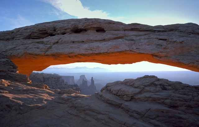
NPS calls Mesa Arch a classic sunrise spot: a 27-foot arch on the cliff edge that frames the La Sal Mountains and the canyon far below. The loop is 0.6 miles, with stone steps and rough footing, and NPS notes photographers often gather before dawn waiting for light on the underside of the arch. Walk clockwise to the arch for fewer stairs. Arrive early; sunrise shifts through the year (about 7:20 AM in early October), so allow roughly 30-45 minutes before it.
- Distance
- 0.6 mi
- Elevation gain
- 56 ft
- Route
- Loop
- Difficulty
- Easy
- Dogs allowed
- No
- Trailhead
- Mesa Arch trailhead, Island in the Sky
- Distance note
- NPS: 0.6 mi round trip loop, 56 ft elevation change, about 30 minutes (longer if waiting for sunrise).
Sources (3)
- NPS Data API - places (cany) · retrieved 2026-10-06
- NPS - Canyonlands hiking · retrieved 2026-10-06
- NPS - Mesa Arch Trail · retrieved 2026-10-06
Green River Overlook
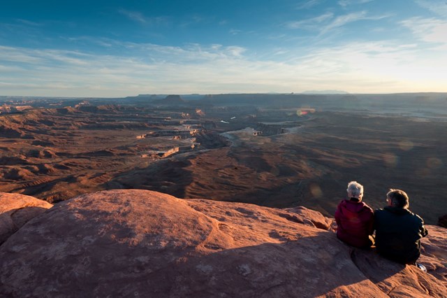
A southwest-facing overlook above the Green River, which NPS places 1,300 feet below in its channel, with the White Rim Road and the Maze district in view. NPS calls it one of the best places on the island to watch the sunset, so it also works as an evening stop; with morning light it is quieter and fits on the way back toward the visitor center.
- Time
- Short roadside viewpoint; 20-30 minutes
- Best time
- Sunset or morning
- Reservation needed
- No
Sources (2)
- NPS Data API - places (cany) · retrieved 2026-10-06
- NPS - Green River Overlook · retrieved 2026-10-06
Shafer Trail Viewpoint
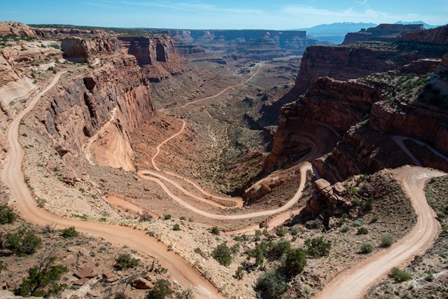
A short drive past the visitor center ends at a view of the Shafer Trail, the unpaved road that drops 1,500 feet through the sandstone cliff, used by herders and later uranium trucks according to NPS. Today it is a rough backcountry road; this plan only looks down on it. It sits on the way out of the park.
- Time
- About 0.9 mi past the visitor center (NPS); 20-30 minutes
- Best time
- Morning to midday
- Reservation needed
- No
Sources (2)
- NPS Data API - places (cany) · retrieved 2026-10-06
- NPS - Shafer Trail Viewpoint · retrieved 2026-10-06
Lunch at Sultan Mediterranean Grill
Lebanese and Greek plates on the north end of Main Street, on the way back into town from the park turnoff. The restaurant's site lists mezze appetizers, kebabs and sandwiches, entrees, salads and lunch specials, and says table reservations are accepted. Its site lists daily hours from 11:30 AM.
- Meal
- Lunch
- Cuisine
- Lebanese, Greek, Mediterranean
- Reservation needed
- No
Sources (2)
- Sultan Mediterranean Grill official site · retrieved 2026-10-06
- OpenStreetMap - Sultan Mediterranean Grill (coordinates) · retrieved 2026-10-06
Where to stay
More options
Needles Option: Pothole Point Trail
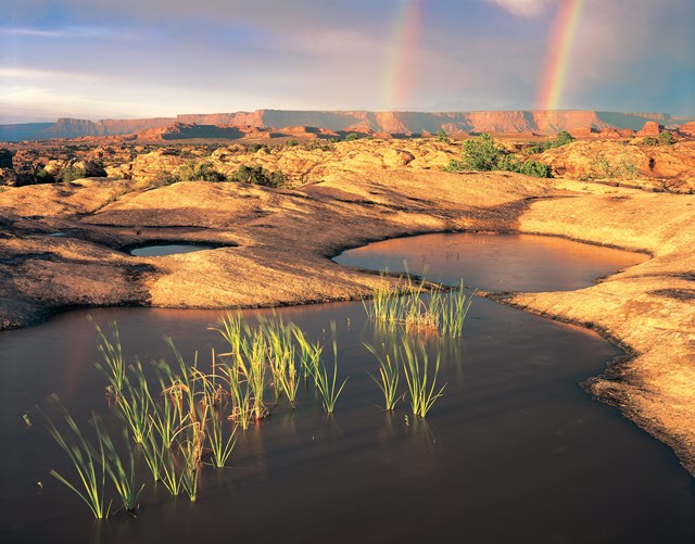
For a different district swap, the Needles offers this short loop over slickrock pocked with potholes that can hold small aquatic life, with views of The Needles on a cairn-marked route. NPS asks visitors to walk around potholes, wet or dry. The Needles is far from Island in the Sky by road, so treat it as a replacement day, not an add-on.
- Distance
- 0.6 mi
- Elevation gain
- 36 ft
- Route
- Loop
- Difficulty
- Easy
- Dogs allowed
- No
- Trailhead
- Pothole Point trailhead, The Needles district
- Distance note
- NPS: 0.6 mi loop, 36 ft elevation change, about 45 minutes.
Sources (2)
- NPS Data API - places (cany) · retrieved 2026-10-06
- NPS - Pothole Point Trail · retrieved 2026-10-06
Needles Option: The Needles Visitor Center
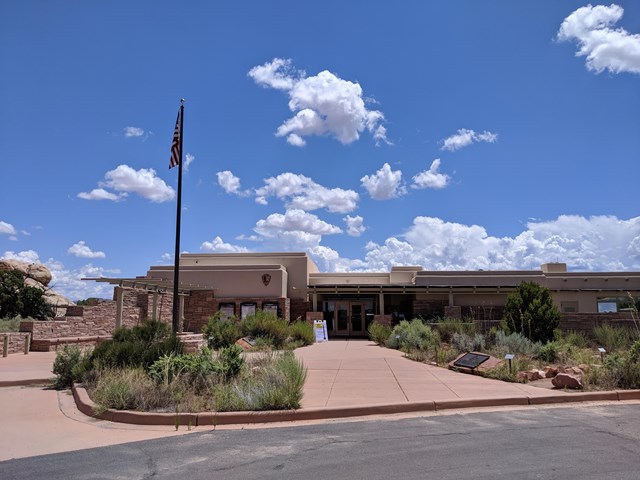
The Needles district's visitor center sells books and maps, issues backcountry permits and has information and a picnic area, with a 15-minute park film on demand. NPS places it at the end of UT 211, about 35 miles west of US 191. Water is available year-round.
- Time
- Allow 20-30 minutes
- Reservation needed
- No
Sources (2)
- NPS Data API - visitor centers (cany) · retrieved 2026-10-06
- NPS - Canyonlands hours and visitor centers · retrieved 2026-10-06
Map of places
- Jailhouse Cafe (opens Google Maps in a new tab) Day 1
- Whale Rock Trail (opens Google Maps in a new tab) Day 1
- Upheaval Dome Overlooks Trailhead (opens Google Maps in a new tab) Day 1
- Grand View Point Overlook and Trail (opens Google Maps in a new tab) Day 1
- The Trailhead Public House and Eatery (opens Google Maps in a new tab) Day 1
- Aarchway Inn (opens Google Maps in a new tab) Day 1
- Mesa Arch Trail (opens Google Maps in a new tab) Day 2
- Green River Overlook (opens Google Maps in a new tab) Day 2
- Shafer Trail Viewpoint (opens Google Maps in a new tab) Day 2
- Sultan Mediterranean Grill (opens Google Maps in a new tab) Day 2
- Moab Springs Ranch (opens Google Maps in a new tab) Option
- Red Cliffs Lodge (opens Google Maps in a new tab) Option
- Island in the Sky (Willow Flat) Campground (opens Google Maps in a new tab) Option
- Pothole Point Trail (opens Google Maps in a new tab) Option
- The Needles Visitor Center (opens Google Maps in a new tab) Option
Good to know
Current conditions (as of 2026-10-06)
- NPS fees: $30 private vehicle, $25 motorcycle, $15 per person on foot or bike; annual park pass $55 (NPS fees page). Timed entry is not required (NPS).
- NPS 2026 trip-planning alert: expect possible long waits at the entrance station, and if overlook or trailhead parking is full, return later. NPS lists heavy traffic March through November, including Utah's October fall break.
- Grand View Point: NPS posted weekday closures in 2026 (its construction page lists July 27-August 27; a May 2026 NPS release lists July 27-October 1), so the closures were over by this date. NPS says a final phase is planned for July-September 2027; check before you go.
- Island in the Sky Visitor Center: 8:00 AM-5:00 PM now, 8:00 AM-4:00 PM from 2026-10-24 to 2026-11-28, then 9:00 AM-4:00 PM from 2026-11-29; early closing 2026-11-26 and 2026-12-24 and closed 2026-12-25 (NPS).
- The Needles Visitor Center: 8:00 AM-4:00 PM from 2026-10-18; NPS API lists it closed 2026-12-06 to 2027-02-13.
- Willow Flat campground is $15 per site and first-come, first-served; The Needles Campground is $20 (NPS).
Evergreen tips
- The park is open 24 hours (NPS), but services are minimal. Bring food, fuel and water; NPS advises at least 1 quart of water per person for short trails.
- Island in the Sky is about 22 miles down UT 313 from US 191 (NPS), which is about 30 to 40 minutes from the north side of Moab by the lodging's account; add time for entrance waits.
- The district is a mesa top: trail footing is rocky and uneven, and NPS recommends traction devices in winter.
- Dogs are not allowed on the Mesa Arch, Whale Rock and Grand View Point trails (NPS); service animals are allowed.
- Do not climb or stand on arches (NPS).
- The Needles and Island in the Sky are separate districts with no connecting road; NPS says travel between districts takes 2 to 6 hours. Backcountry 4x4 roads like the White Rim and The Maze are outside this plan.
- Arches National Park is nearby and has its own trip in this collection; this plan avoids repeating its Moab stops.
Want live alerts and up-to-date info?
Conditions change fast. Create an account on the DriftKin app to get live park alerts, closures and information for your trip.
Sources
Good to know: distances and drive times are typical figures without live traffic, and where routes are shown the route data comes from OpenStreetMap contributors. Toll amounts are estimates and change often, so check them in the DriftKin planner or with the toll authority before you plan around them. Opening hours, fees, prices, permits and closures also change, so confirm with the park or business before you go.
- Discover Moab - Fine Dining to Food Trucks (hours) retrieved 2026-10-06
- OpenStreetMap - Jailhouse Cafe (coordinates) retrieved 2026-10-06
- NPS Data API - places (cany) retrieved 2026-10-06
- NPS - Canyonlands hiking retrieved 2026-10-06
- NPS - Whale Rock Trail retrieved 2026-10-06
- NPS - Upheaval Dome Overlooks Trail retrieved 2026-10-06
- NPS - Upheaval Dome retrieved 2026-10-06
- NPS - Grand View Point Overlook and Trail retrieved 2026-10-06
- The Trailhead Public House and Eatery official site (no hours listed) retrieved 2026-10-06
- OpenStreetMap - Trailhead Public House (coordinates) retrieved 2026-10-06
- Aarchway Inn official site retrieved 2026-10-06
- OpenStreetMap - Aarchway Inn (coordinates) retrieved 2026-10-06
- NPS - Mesa Arch Trail retrieved 2026-10-06
- NPS - Green River Overlook retrieved 2026-10-06
- NPS - Shafer Trail Viewpoint retrieved 2026-10-06
- Sultan Mediterranean Grill official site retrieved 2026-10-06
- OpenStreetMap - Sultan Mediterranean Grill (coordinates) retrieved 2026-10-06
- Moab Springs Ranch official site retrieved 2026-09-30
- Red Cliffs Lodge Moab official site retrieved 2026-09-30
- OpenStreetMap: Red Cliffs Lodge (location) retrieved 2026-10-01
- NPS Data API - campgrounds (cany) retrieved 2026-10-06
- NPS - Island in the Sky Campground retrieved 2026-10-06
- NPS - Pothole Point Trail retrieved 2026-10-06
- NPS Data API - visitor centers (cany) retrieved 2026-10-06
- NPS - Canyonlands hours and visitor centers retrieved 2026-10-06