Sequoia: 2 Days Among the Giants
Moro Rock, the Sherman Tree and Tokopah Falls from a lodge in the Giant Forest
- Length
- 2 days
- Difficulty
- Moderate
- Best months
- Jun–Jul, Sep–Oct
- Budget
- $$
Two relaxed days in Sequoia's high country: a staircase climb up Moro Rock, wandering Crescent Meadow, a visit to the General Sherman Tree and a canyon walk to Tokopah Falls. Based at Wuksachi Lodge so mountain driving stays short.
- Climb the 350-step Moro Rock staircase
- Walk Crescent Meadow past Tharp's Log and Tunnel Log
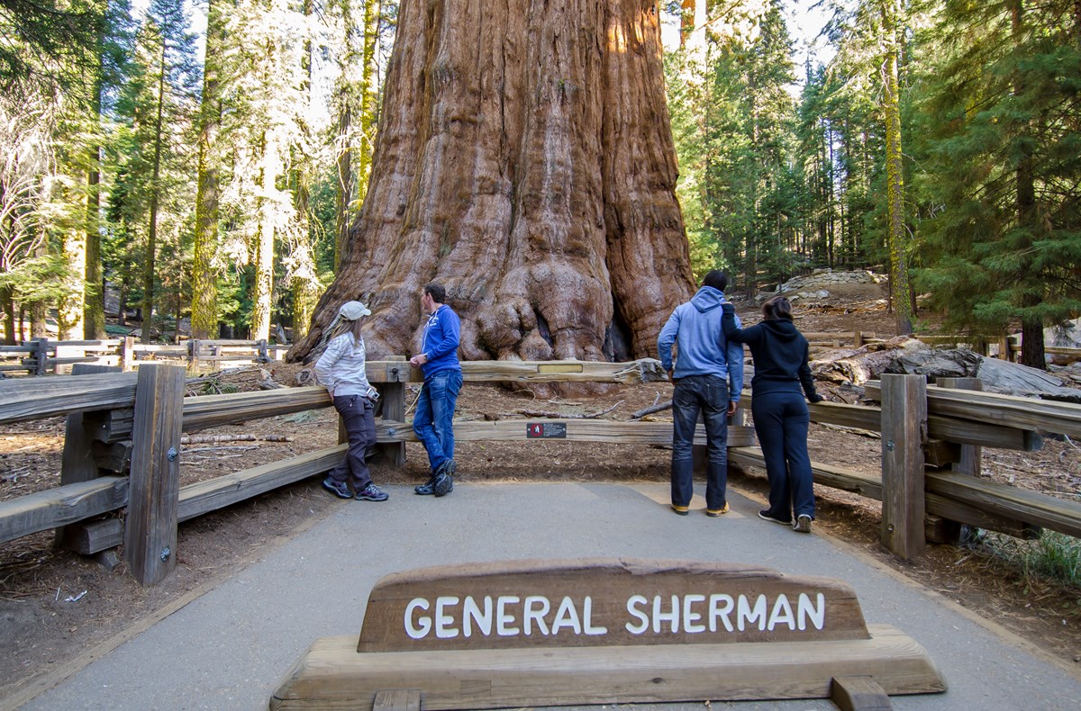
- Stand beside the General Sherman Tree
- Hike easy-grade Tokopah Falls canyon
- Stay in-park at Wuksachi Lodge
The story
Sequoia is a park of scale, and most of its best moments sit within a few miles of each other in the Giant Forest, 6,500 to 7,000 feet up the Generals Highway. This plan spends two days there and keeps the driving short by sleeping inside the park at Wuksachi Lodge.
Day one starts early at Moro Rock, a 350-step granite staircase with views over the Great Western Divide, then slows down at Crescent Meadow, where a flat loop passes Tharp's Log and a drive through Tunnel Log is on the way. After lunch at Lodgepole, you walk down to the General Sherman Tree, the largest tree on Earth by volume, then settle in for dinner at the lodge.
Day two heads up the Marble Fork of the Kaweah to Tokopah Falls, an easy 3.4-mile walk beneath granite cliffs, then returns to the Giant Forest Museum for the Big Trees Trail and a quiet late-afternoon seat at Sunset Rock before you drive down.
The pace is deliberately conservative. The highway from the park entrance is narrow, curvy and slow (about an hour to Giant Forest), and it can require chains from fall through spring, so build in margin. Summer and early fall suit this plan best.
Day by day
Moro Rock, Crescent Meadow and the Sherman Tree
Start at the south end of the Giant Forest with the big view, wander the meadow, then meet the Sherman Tree before dinner at the lodge. Plan about 70 minutes from the entrance station to Moro Rock.
Moro Rock Staircase
A 350-step stone-and-concrete staircase climbs about 300 feet to the top of a granite dome. The reward is a 360-degree view of the Great Western Divide and, on clear days, out to the San Joaquin Valley. Do it first, while the small parking area has space and the air is cool. NPS says to skip it if snow or ice is on the stairs and to get down if thunderstorms threaten.
- Distance
- 0.5 mi
- Elevation gain
- 300 ft
- Route
- Out and back
- Difficulty
- Moderate
- Dogs allowed
- No
- Trailhead
- Moro Rock parking area, about 2 miles off the Generals Highway
- Distance note
- NPS: the staircase climbs 300 ft over about 0.25 mi; 0.5 mi is the round trip derived from that. Gain is one-way up; you return the same way.
Sources (5)
- NPS Data API - places (seki; Sequoia & Kings Canyon) · retrieved 2026-10-03
- NPS - Moro Rock (place) · retrieved 2026-10-03
- NPS - Giant Forest & Lodgepole Day Hikes · retrieved 2026-10-03
- NPS - Road Information · retrieved 2026-10-03
- NPS - Moro Rock · retrieved 2026-10-03
Crescent Meadow, Tharp's Log and Tunnel Log
Drive the Moro Rock / Crescent Meadow Road past Tunnel Log, a fallen sequoia cut through in the 1930s (vehicles over 8 feet tall use a bypass). At the road's end, a mostly flat loop of about 1.8 miles circles Crescent Meadow, then visits Tharp's Log, the cabin Hale Tharp built into a fallen sequoia log in the mid-1800s, and the fire-hollowed Chimney Tree. Bears are often seen in the meadows, so keep your distance.
- Time
- About 1.8 miles round trip on the NPS-described loop; mostly flat, partly paved.
- Best time
- Early morning, when sun lights the red sequoia bark
- Reservation needed
- No
Sources (5)
- NPS Data API - things to do (seki; Sequoia & Kings Canyon) · retrieved 2026-10-03
- NPS - Crescent Meadow Picnic Area and Trailhead · retrieved 2026-10-03
- NPS - Tharp's Log · retrieved 2026-10-03
- NPS - Crescent Meadow · retrieved 2026-10-03
- NPS - Tunnel Log · retrieved 2026-10-03
Lunch at Lodgepole Market and Grill
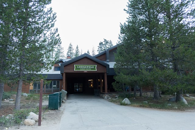
The Lodgepole Grill serves burgers, sandwiches, salads and snacks, and the attached market sells prepackaged sandwiches and groceries, so it works for a sit-down meal or a picnic to carry to the trail. It is the practical lunch stop between the Giant Forest and Wuksachi.
- Meal
- Lunch
- Cuisine
- Grill, sandwiches, groceries
- Reservation needed
- No
Sources (3)
- NPS Data API - places (seki; Sequoia & Kings Canyon) · retrieved 2026-10-03
- NPS - Lodgepole Market Center · retrieved 2026-10-03
- Delaware North - Lodgepole Grill, Market and Snack Bar · retrieved 2026-10-03
General Sherman Tree
The Sherman Tree holds more wood in its trunk than any other tree on Earth, per NPS, and is estimated at about 2,200 years old. From the main parking lot it is a 0.5-mile walk down, with some stairs, so the return is uphill at roughly 7,000 feet. Parking usually fills by mid-morning in busy periods; Wolverton's large lot and the summer shuttle are the fallback.
- Time
- About 0.5 mile each way from the main lot (descending, some stairs); an accessible trail starts from a separate small lot on the Generals Highway.
- Best time
- Early or late in the day
- Reservation needed
- No
Sources (3)
- NPS Data API - places (seki; Sequoia & Kings Canyon) · retrieved 2026-10-03
- NPS - Giant Forest & Lodgepole Day Hikes · retrieved 2026-10-03
- NPS - The General Sherman Tree · retrieved 2026-10-03
Wuksachi Lodge
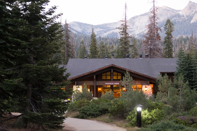
The lodge in Sequoia's Giant Forest area, with 102 rooms in the Giant Forest area, about 2 miles from Lodgepole and 4 miles from the Giant Forest Museum. Staying here puts both days' stops within a short drive and saves a long mountain-road commute. Check-in is 4 PM per the operator's site.
- Type
- Lodge
- Location
- Inside the park
- Booking
- Book / details
- Reservation notes
- Check current rates and availability; book well ahead for summer.
Sources (3)
- NPS - Wuksachi Restaurant & Lodge · retrieved 2026-10-03
- NPS - Lodging · retrieved 2026-10-03
- Delaware North - Wuksachi Lodge · retrieved 2026-10-03
Dinner at The Peaks Restaurant
The Peaks, the lodge's restaurant, serves seasonal California dishes with vegan, gluten-free and low-carb options listed on the operator's site. It states reservations are required for dinner, especially in summer, so book when you reserve the room.
- Meal
- Dinner
- Cuisine
- Seasonal California
- Reservation needed
- Yes
Sources (2)
- NPS - Wuksachi Restaurant & Lodge · retrieved 2026-10-03
- Delaware North - The Peaks Restaurant · retrieved 2026-10-03
Tokopah Falls, Giant Forest Museum and Sunset Rock
An easy canyon hike to a 1,200-foot waterfall, then a gentler afternoon in the Giant Forest before the drive out.
Tokopah Falls Trail
An easy-grade walk up the Marble Fork of the Kaweah River into a glacier-carved canyon, ending beneath the 1,200-foot Tokopah Falls. The trail has no sequoias, but NPS calls it the easiest way to glimpse the park's high country. Marmots often sunbathe on the rocks. The falls are strongest in late spring and early summer snowmelt, and NPS warns of strong currents near the water.
- Distance
- 3.4 mi
- Elevation gain
- 600 ft
- Route
- Out and back
- Difficulty
- Easy
- Dogs allowed
- No
- Trailhead
- Just past the Marble Fork bridge in Lodgepole Campground; park in the large lot by the campground entrance
- Distance note
- NPS: 3.4 mi round trip with 600 ft of elevation change (the Giant Forest day-hike page gives 1.7 mi one-way, which agrees). The 600 ft is NPS's elevation-change figure, taken as gain on the way up. Allow about 2 hours.
Sources (4)
- NPS Data API - places (seki; Sequoia & Kings Canyon) · retrieved 2026-10-03
- NPS - Tokopah Falls Trailhead · retrieved 2026-10-03
- NPS - Discover Tokopah Valley and Falls · retrieved 2026-10-03
- NPS - Tokopah Falls · retrieved 2026-10-03
Giant Forest Museum and Big Trees Trail
The museum, in a historic market building, has hands-on exhibits on giant sequoia ecology, maps and a park store. Just outside, the paved Big Trees Trail loops Round Meadow for about 0.75 mile (NPS suggests allowing an hour), with panels on how sequoias live. It is flat and an easy way to ease the legs after Tokopah.
- Time
- Big Trees Trail: about 0.75 mile paved loop, essentially flat (NPS lists 0.7 and 0.75 mi).
- Reservation needed
- No
Sources (4)
- NPS Data API - visitor centers (seki; Sequoia & Kings Canyon) · retrieved 2026-10-03
- NPS - Giant Forest & Lodgepole Day Hikes · retrieved 2026-10-03
- NPS - Visitor Centers · retrieved 2026-10-03
- NPS - Big Trees Trail · retrieved 2026-10-03
Sunset Rock
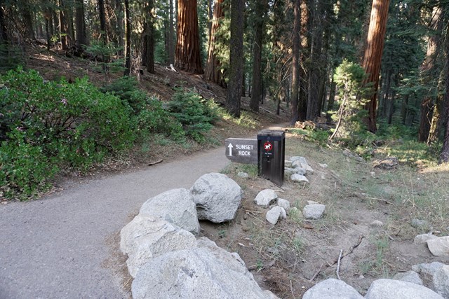
A gentle 1.4-mile round-trip walk from the Giant Forest Museum through mixed conifers ends on a granite dome overlooking the canyon of the Kaweah River and the foothills beyond. NPS suggests it for sunset; this plan visits mid-afternoon so you can drive out in daylight, and you can move it later if you are staying overnight.
- Time
- 1.4 miles round trip (NPS); easy, unpaved with some rock steps.
- Best time
- Late afternoon to sunset
- Reservation needed
- No
Sources (3)
- NPS Data API - things to do (seki; Sequoia & Kings Canyon) · retrieved 2026-10-03
- NPS - Sunset Rock Trailhead · retrieved 2026-10-03
- NPS - Sunset Rock Trail · retrieved 2026-10-03
Where to stay
Buckeye Tree Lodge
A budget-to-mid option in Three Rivers about a minute from the park entrance, with 12 rooms and 10 cabins, salt-water pools and river access per its own site. Choosing it adds roughly an hour of mountain driving each way to the Giant Forest.
- Type
- Hotel
- Location
- Outside the park
- Booking
- Book / details
- Reservation notes
- Check current rates on the lodge's site.
Sources (1)
- Buckeye Tree Lodge - official site · retrieved 2026-10-03
John Muir Lodge (Grant Grove)
A 36-room lodge in Grant Grove Village, Kings Canyon National Park, about half a mile from a sequoia grove, a visitor center and a restaurant. Handy if you plan to continue to Grant Grove or exit north on Highway 180, but it is a longer drive from Sequoia's Giant Forest.

- Type
- Lodge
- Location
- Inside the park
- Booking
- Book / details
- Reservation notes
- Check current rates and availability.
Sources (2)
- NPS - Lodging · retrieved 2026-10-03
- Delaware North - John Muir Lodge · retrieved 2026-10-03
Lodgepole Campground
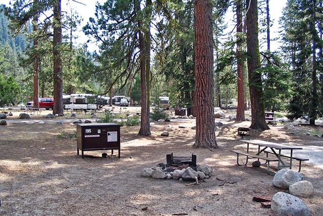
A large reservation-only campground on the Marble Fork of the Kaweah River within walking distance of Lodgepole Village, the Tokopah Falls trailhead and the summer shuttle. Typically open May through November; reserve on Recreation.gov up to four months ahead.
- Type
- Campground
- Location
- Inside the park
- Price per night
- From $32 (as of 2026-10-03)
- Booking
- Book / details
- Reservation notes
- Per night for up to six people (NPS); reservation only via Recreation.gov.
Sources (2)
- NPS Data API - campgrounds (seki; Sequoia & Kings Canyon) · retrieved 2026-10-03
- NPS - Lodgepole Campground · retrieved 2026-10-03
Map of places
- Moro Rock (opens Google Maps in a new tab) Day 1
- Crescent Meadow Picnic Area and Trailhead (opens Google Maps in a new tab) Day 1
- Lodgepole Market Center (opens Google Maps in a new tab) Day 1
- General Sherman Tree (opens Google Maps in a new tab) Day 1
- Wuksachi Lodge (opens Google Maps in a new tab) Day 1
- The Peaks Restaurant at Wuksachi Lodge (opens Google Maps in a new tab) Day 1
- Tokopah Falls Trailhead (opens Google Maps in a new tab) Day 2
- Giant Forest Museum (opens Google Maps in a new tab) Day 2
- Sunset Rock Trailhead (opens Google Maps in a new tab) Day 2
- John Muir Lodge (opens Google Maps in a new tab) Option
- Lodgepole Campground (opens Google Maps in a new tab) Option
Good to know
Current conditions (as of 2026-10-03)
- NPS lists weekday traffic delays of up to 30 minutes (8 AM-5 PM, not on federal holidays) on the Generals Highway between the park's north boundary and Wuksachi Way for hazard-tree removal; this matters only if you enter or leave via Highway 180.
- NPS lists Stage 1 fire restrictions: wood and charcoal fires prohibited at low-elevation campgrounds and picnic areas.
- Private-vehicle entrance fee is $35 (valid 1-7 days, covers Sequoia and Kings Canyon); the park accepts cards only, not cash (NPS).
- Giant Forest Museum is listed as 9 AM-5 PM through Oct 12, then 9 AM-4:30 PM through Jan 3. Lodgepole Visitor Center typically closes in mid-October.
- Free Sequoia Shuttles ran May 22-Sept 7, 2026; for 2026-27 NPS lists limited holiday dates (Nov 26-29, then tentatively Dec 24-Jan 1 and winter holiday weekends).
- A section of the Congress Trail was under reconstruction through September 2026; this itinerary does not depend on it.
Evergreen tips
- Drive time: NPS gives about 60 minutes for the 16 miles from Foothills Visitor Center to Giant Forest Museum. The road is narrow and curvy; use pullouts. There are no gas stations or EV chargers inside the park (NPS).
- RVs and trailers: NPS advises against vehicles over 22 feet between Potwisha Campground and Giant Forest Museum; use the Highway 180 / Big Stump entrance instead.
- Chains: carry chains from fall through late spring; chain control is usually November-March, and conditions can change within hours. The Generals Highway north of Wuksachi is unplowed from the Friday after January 1 to the third Friday of March.
- Moro Rock / Crescent Meadow Road typically opens by the Wednesday before Memorial Day; in shuttle season it closes to private cars on weekends and holidays, so use the free shuttle from Giant Forest Museum.
- Parking at Giant Forest Museum and the Sherman Tree is often full by mid-morning in busy periods; Wolverton's lot is larger.
- Store food in the bear boxes; pets are not allowed on trails. Elevation is 6,500-7,000 ft in Giant Forest, so take stairs slowly.
- Best months: June-July for Tokopah Falls flow and open roads; September-October for cooler, quieter days (first snow possible by late October).
Want live alerts and up-to-date info?
Conditions change fast. Create an account on the DriftKin app to get live park alerts, closures and information for your trip.
Sources
Good to know: distances and drive times are typical figures without live traffic, and where routes are shown the route data comes from OpenStreetMap contributors. Toll amounts are estimates and change often, so check them in the DriftKin planner or with the toll authority before you plan around them. Opening hours, fees, prices, permits and closures also change, so confirm with the park or business before you go.
- NPS Data API - places (seki; Sequoia & Kings Canyon) retrieved 2026-10-03
- NPS - Moro Rock (place) retrieved 2026-10-03
- NPS - Giant Forest & Lodgepole Day Hikes retrieved 2026-10-03
- NPS - Road Information retrieved 2026-10-03
- NPS - Moro Rock retrieved 2026-10-03
- NPS Data API - things to do (seki; Sequoia & Kings Canyon) retrieved 2026-10-03
- NPS - Crescent Meadow Picnic Area and Trailhead retrieved 2026-10-03
- NPS - Tharp's Log retrieved 2026-10-03
- NPS - Crescent Meadow retrieved 2026-10-03
- NPS - Tunnel Log retrieved 2026-10-03
- NPS - Lodgepole Market Center retrieved 2026-10-03
- Delaware North - Lodgepole Grill, Market and Snack Bar retrieved 2026-10-03
- NPS - The General Sherman Tree retrieved 2026-10-03
- NPS - Wuksachi Restaurant & Lodge retrieved 2026-10-03
- NPS - Lodging retrieved 2026-10-03
- Delaware North - Wuksachi Lodge retrieved 2026-10-03
- Delaware North - The Peaks Restaurant retrieved 2026-10-03
- NPS - Tokopah Falls Trailhead retrieved 2026-10-03
- NPS - Discover Tokopah Valley and Falls retrieved 2026-10-03
- NPS - Tokopah Falls retrieved 2026-10-03
- NPS Data API - visitor centers (seki; Sequoia & Kings Canyon) retrieved 2026-10-03
- NPS - Visitor Centers retrieved 2026-10-03
- NPS - Big Trees Trail retrieved 2026-10-03
- NPS - Sunset Rock Trailhead retrieved 2026-10-03
- NPS - Sunset Rock Trail retrieved 2026-10-03
- Buckeye Tree Lodge - official site retrieved 2026-10-03
- Delaware North - John Muir Lodge retrieved 2026-10-03
- NPS Data API - campgrounds (seki; Sequoia & Kings Canyon) retrieved 2026-10-03
- NPS - Lodgepole Campground retrieved 2026-10-03
More trips like this
 National parkCuyahoga Valley
Cuyahoga Valley: 3 Days of Waterfalls, Ledges and the Canal Towpath
3 days Moderate$$$ National parkIndiana Dunes
Indiana Dunes: 3 Days of Dunes, Bogs and Lake Michigan Shore
3 days Moderate$$ National parkGrand Teton
Grand Teton: 4 Days of Lakes, Peaks and Jackson Hole Light
4 days Moderate$$