New River Gorge: 3 Days of Bridge Views, Rail Ruins and Rim Trails
Cliff-edge overlooks, a coal-and-rail ghost town and the New River's biggest waterfall
- Length
- 3 days
- Difficulty
- Moderate
- Best months
- May–Jun, Sep–Oct
- Budget
- $$
Three days on America's newest national park: cliff-top trails and the famous bridge near Fayetteville, a steep Friday-to-Sunday descent to the Kaymoor coke ovens and the ghost town of Thurmond, then Grandview's rim and Sandstone Falls. Free entry, primitive campgrounds, and a rafting base camp for lodging.
- Endless Wall cliff-edge trail and Diamond Point overlook
- Canyon Rim overlooks and Long Point views of the New River Gorge Bridge
- Fayette Station Road drive beneath the bridge
- Kaymoor Miners Trail descent past a coal mine site to the coke ovens (Fri-Sun)
- Thurmond, a preserved coal and railroad boomtown
- Grandview Main Overlook and Castle Rock Trail
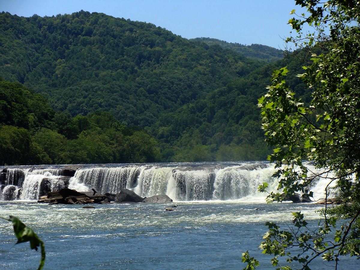
- Sandstone Falls boardwalk on the New River's largest waterfall
The story
The gorge the New River has carved through West Virginia snaps into focus the first time you stand at its rim. This plan uses that rim, the river below it and the industrial ruins scattered along the way to build three days that feel varied rather than repetitive.
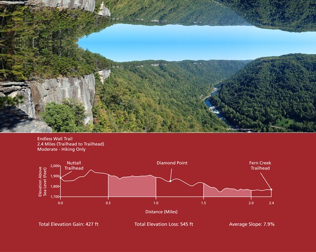
Day one is the bridge day, and it starts at Endless Wall, where NPS describes a trail that zig-zags along the cliff edge with vista after vista; the plan walks the roughly two-mile round trip to Diamond Point. From there it is a few minutes to Canyon Rim Visitor Center for the boardwalk overlooks of the New River Gorge Bridge, then a sandwich in Fayetteville, an afternoon at Long Point with its head-on bridge view, and an evening drive down Fayette Station Road, which passes directly beneath the span.
Day two heads down into history. The Kaymoor Miners Trail is short but punishing, dropping about 900 feet in a mile past the mine site and down hundreds of wooden steps to the coke ovens near the river. Its upper section is typically open only Friday to Sunday in the fall, so plan this as a weekend day (Thurmond's depot is also typically open only weekends in September and October). After a picnic, the road to Thurmond winds to a town that was once a shipping hub for coal; NPS notes its railroad operation ranked first in revenue in 1910. Today the depot, commissary and bank buildings stand beside the working tracks, and the ruins of the Lafayette Hotel sit up the block. Dunloup Falls makes a fitting last stop on the drive out.
Day three goes south. Grandview is the highest point in the park, with a horseshoe bend of the New River about 1,400 feet below and the rocky Castle Rock Trail beneath fortress-like cliffs. From there the plan runs to Sandstone, where the visitor center offers picnic tables and exhibits, the overlook shows Sandstone Falls from about 600 feet above, and a quarter-mile accessible boardwalk puts you among the falls themselves, the largest on the New River at about 1,500 feet across.
A few things make this easy to plan: NPS charges no entrance fee, camping in the park's primitive campgrounds is free and first-come, and the rafting outfitters around Lansing provide lodging for those who want a real bed. Bring layers, sturdy shoes and a picnic. Because the Kaymoor trail's upper section is typically closed Monday to Thursday during rehab work, put Day 2 on a Friday, Saturday or Sunday; the tips give a weekday swap.
Day by day
Gorge Rim and the Bridge
Cliff-edge walking on the Endless Wall trail out to Diamond Point, the bridge overlooks at Canyon Rim, lunch in Fayetteville, the Long Point view and a late-day drive under the span. Everything is within about 15 minutes of Fayetteville, so there is almost no backtracking.
Endless Wall to Diamond Point (about 2 miles round trip)
Start where the gorge is most theatrical: a forest walk that crosses Fern Creek and then zig-zags along the cliff edge, with one vista after another. NPS calls it a moderate walk and suggests the overlook at Diamond Point as a natural turnaround, which makes a popular out-and-back of about two miles round trip from the Fern Creek trailhead parking area. Go early; NPS's trail-running page warns the narrow path gets crowded with other hikers later in the day.
The full Endless Wall Trail is 2.4 miles one way and continues to the Nuttall end, but that would need a half-mile road walk or a second car to get back, so this plan turns around at Diamond Point. NPS does not publish an elevation gain for the shorter out-and-back, so none is claimed. Stay well back from the unfenced cliff edges.
- Time
- About 2 miles round trip to Diamond Point and back (NPS); time is a planning estimate
- Trailhead
- Fern Creek trailhead
- Difficulty
- moderate
- Dogs allowed
- Yes
Sources (4)
- NPS Data API: Endless Wall Trail place record · retrieved 2026-09-29
- NPS Data API: trail running at New River Gorge (crowding note) · retrieved 2026-09-29
- NPS: Hiking at New River Gorge · retrieved 2026-09-29
- NPS: Endless Wall Trail · retrieved 2026-09-29
Canyon Rim Visitor Center and Bridge Overlooks
Only a few minutes from the trailhead, this is the park's front porch for the New River Gorge Bridge. Pick up a map, watch the park film and browse exhibits, then walk the wooden boardwalk to the overlooks for the classic straight-on view of the bridge and river below. NPS notes no hiking trails start here; the walk is short and easy.
- Time
- Overlooks are 0-30 minutes on their own (NPS); allow more for exhibits and the film
- Best time
- Any time; morning light is quieter
Sources (2)
- NPS Data API: View the Overlooks at the Canyon Rim Visitor Center · retrieved 2026-09-29
- NPS Data API: Canyon Rim Visitor Center · retrieved 2026-09-29
Lunch at Secret Sandwich Society
A short hop into Fayetteville gets you a sandwich-focused menu. The restaurant's own site says it uses premium beef, pork, deli meats and all-natural chicken breast and also serves cocktails and beer. The site asks diners to be mindful of neighbors and park in front or on Court Street.
- Meal
- Lunch
- Cuisine
- Sandwiches
Sources (1)
- Secret Sandwich Society official site (Fayetteville location) · retrieved 2026-09-29
Long Point Trail to the Bridge Overlook
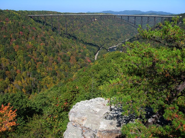
Long Point is the payoff for a quiet afternoon: a trail through field and forest to a rock outcrop with a panoramic view of the gorge and the New River Gorge Bridge. NPS says most of the trail lazily descends, with one steep section just before the point, so the return is a gentle uphill. The route is 1.6 miles one way (about 3.2 round trip). NPS does not publish an elevation gain, so it is typed as an activity here. Use caution: the cliff edges at the point are unprotected. Mountain bikes are banned on the last 0.2 miles.
- Time
- 3.2 miles round trip (NPS: 1.6 mi one way); time is a planning estimate
- Difficulty
- moderate
- Dogs allowed
- Yes
Sources (2)
- NPS Data API: Long Point Trail · retrieved 2026-09-29
- NPS: Long Point Trail · retrieved 2026-09-29
Fayette Station Road Late-Afternoon Drive
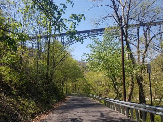
End the day by dropping to river level. This 8-mile one-way route runs from Canyon Rim Visitor Center down a series of hairpin turns, passes directly under the New River Gorge Bridge, goes through the old town sites of Fayette and South Fayette, crosses the Tunney Hunsaker Bridge and climbs out the other side. A parking area a tenth of a mile past the bridge gives an up-close look at Fayette Station Rapid. NPS lists it at about 45 minutes.
- Time
- 8 miles one way, about 45 minutes per NPS, longer with stops
- Best time
- Late afternoon
- Fee
- Free
Sources (2)
- NPS Data API: Scenic Drive on Fayette Station Road · retrieved 2026-09-29
- NPS: Fayette Station Road · retrieved 2026-09-29
Stay: Adventures on the Gorge (Lansing)
This private resort near the bridge offers a range from rustic bunk cabins with shared bathrooms (linens not included) to hotel-style and loft cabins, glamping tents, RV and tent sites and vacation homes, plus on-site rafting, ziplines and dining. It puts you a short drive from the Day 1 and Day 2 starting points. The resort site does not publish rates on the pages reviewed, so price is not listed here.
- Type
- Cabin
- Location
- Outside the park
- Booking
- Book / details
- Reservation notes
- Book through the resort; rates not published on the pages reviewed.
Sources (3)
- Google Maps pin linked from the AOTG site footer (coordinates) · retrieved 2026-09-29
- Adventures on the Gorge official site · retrieved 2026-09-29
- AOTG: Rustic Cabins · retrieved 2026-09-29
Down the Gorge and Into Thurmond (Fri-Sun)
A steep morning descent on the Kaymoor Miners Trail, a picnic, and the historic town of Thurmond, with Dunloup Falls on the way out. Plan this day for a Friday, Saturday or Sunday, when the upper Kaymoor trail is typically open; Saturday or Sunday also catches the Thurmond Depot visitor center in fall. On a Monday-Thursday, see the weekday swap in the tips.
Kaymoor Miners Trail to the Coke Ovens
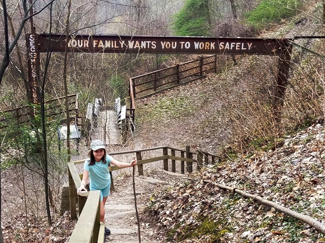
Today is the leg-burner, and it works best Friday through Sunday: the upper trail (Kaymoor Top to the mine site) is typically closed Monday-Thursday during its rehab season, so check current dates. The trail drops steeply from the rim through forest, with rocky stairs and switchbacks. There is a gorge viewpoint 0.2 miles down, and the Kaymoor mine site sits 0.5 miles down (NPS). Below it, wooden stairs (NPS cites 821 steps) continue toward the coke ovens near river level. NPS gives 1.0 mile and a 900 ft descent for the whole trail. Do not walk on the active railroad tracks at river level; they are private property.
The data below are for the round trip to the coke ovens, about 2 miles, with roughly 900 ft to climb back out (taken as equal to NPS's descent figure). If your legs say stop early, turn around at the mine site (0.5 mi one way).
- Distance
- 2 mi
- Elevation gain
- 900 ft
- Route
- Out and back
- Difficulty
- Strenuous
- Permit required
- No
- Dogs allowed
- Yes
- Trailhead
- Kaymoor Top
- Distance basis
- Round trip to the coke ovens (NPS: 1.0 mi one way, 900 ft descent); gain is the climb back out, taken as equal to the NPS descent figure
Sources (3)
- NPS Data API: alerts · retrieved 2026-09-29
- NPS Data API: Kaymoor Miners Trail · retrieved 2026-09-29
- NPS: Kaymoor Miners Trail · retrieved 2026-09-29
Pick Up a Picnic in Fayetteville
Thurmond has no automotive services, and NPS notes the town is small, so buy sandwiches and water in Fayetteville before you leave. Eat on a bench near the depot or on the drive.
Sources (1)
- NPS Data API: Thurmond Depot Visitor Center directions (no automotive services) · retrieved 2026-09-29
Thurmond Historic District Walking Tour
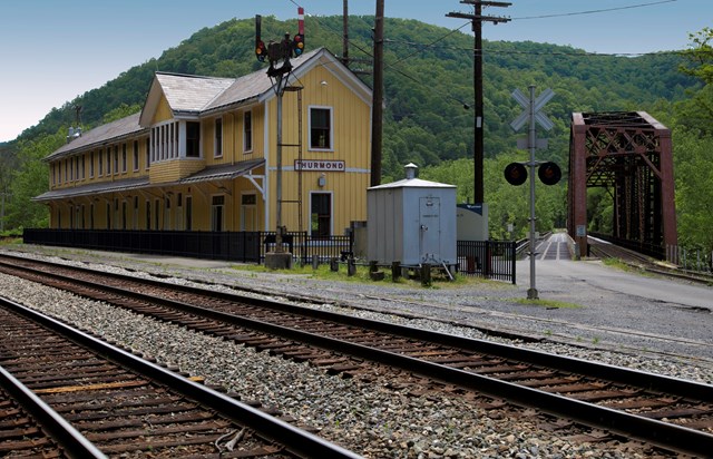
Thurmond was a coal-and-rail boomtown in the early 1900s; NPS says its C&O operation was first in revenue receipts in 1910, and its banks were among the richest in the state. Today the depot, commissary, bank, engine house and the ruins of the Lafayette Hotel line up along the tracks, and the NPS walking tour has numbered stops. The restored Thurmond Depot serves as a visitor center that is typically open daily in summer and weekends only in September and October (see the tips for current dates). The road in is WV Route 25 from the Glen Jean exit, seven miles of narrow, winding road that NPS does not recommend for RVs and trailers.
- Time
- Self-guided; about 2 hours
- Best time
- Saturday or Sunday in fall, when the depot visitor center is typically open
- Reservation needed
- No
Sources (3)
- NPS Data API: Thurmond Historic District · retrieved 2026-09-29
- NPS Data API: Thurmond Depot Visitor Center · retrieved 2026-09-29
- NPS: Thurmond Historic District · retrieved 2026-09-29
Dunloup Falls Roadside Stop
On the way back up the road from Thurmond, pull off for Dunloup Falls, where Dunloup Creek drops about 20 feet off a shelf of sandstone. NPS lists it as stop 5 of the park's waterfall tour and says lucky visitors may see a coal train on the tracks just above the falls. Flow depends on recent rain.
- Time
- Roadside stop
- Best time
- After rain
Sources (2)
- NPS Data API: Dunloup Falls · retrieved 2026-09-29
- NPS: Waterfall tour · retrieved 2026-09-29
Grandview Rim and Sandstone Falls
Early views at Grandview (leave Fayetteville about 7:00 AM; mapping tools show roughly 50 minutes), the Castle Rock loop, then south to Sandstone for a visitor center picnic and the falls from above and from the boardwalk.
Grandview Main Overlook
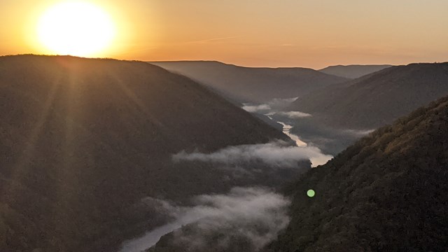
Grandview is the highest point in the park, with a view down into a horseshoe bend of the New River about 1,400 feet below. NPS says the overlook is open year-round and calls sunrise a big draw; in warm months you may spot rafters far below. Get there early, before the walks.
- Time
- 15 minutes per NPS; more for photos
- Best time
- Sunrise or early morning
Sources (2)
- NPS Data API: Grandview Main Overlook · retrieved 2026-09-29
- NPS: Grandview Rim Trail · retrieved 2026-09-29
Castle Rock and Grandview Rim Loop
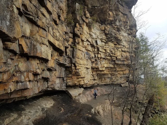
NPS calls Castle Rock the most unique and fun trail here, and also strenuous. It runs 0.6 miles from near Main Overlook beneath fortress-like rock walls with exposed coal seams, on uneven rock steps about 3 feet wide with the gorge just off to one side. Turn left at the junction with the Grandview Rim Trail and you return to the parking area for about 1.1 miles in total (NPS), a great one-mile-scale loop under the overhanging cliffs and past the rim views. Add Turkey Spur for about 3.2 miles total (NPS). Skip Castle Rock in rain, ice or snow. NPS does not publish elevation gain, so this is typed as an activity.
- Time
- Loop about 1.1 miles; with Turkey Spur about 3.2 miles (NPS)
- Difficulty
- strenuous
- Dogs allowed
- Yes
Sources (2)
- NPS Data API: Castle Rock Hike · retrieved 2026-09-29
- NPS: Castle Rock Trail · retrieved 2026-09-29
Sandstone Visitor Center and Picnic Lunch
A green-design building with exhibits on the New River watershed, a park film, a native plant garden, picnic areas and a bookstore. NPS lists it as open daily 9-5. Eat the picnic you brought here before the second half of the day.
- Time
- About an hour with lunch
Sources (1)
- NPS Data API: Sandstone Visitor Center · retrieved 2026-09-29
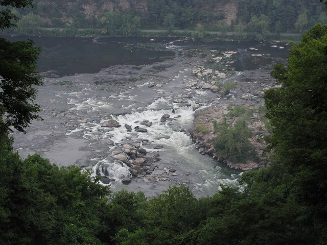
Sandstone Falls Overlook
A short gravel walkway descends from the parking lot to a view of the falls and river about 600 feet below. NPS says the overlook is 3 miles south of I-64 exit 139 on WV 20, and it is the high-flyer's perspective before you go down to river level.
- Time
- 0.1 mile walkway (NPS)
Sources (2)
- NPS Data API: Sandstone Falls Overlook · retrieved 2026-09-29
- NPS: Sandstone Falls Overlook · retrieved 2026-09-29
Sandstone Falls Boardwalk
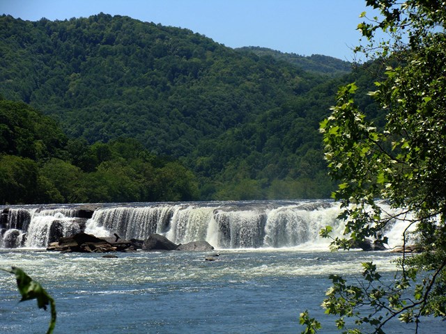
The largest waterfall on the New River spans about 1,500 feet, split by islands into drops of 10 to 25 feet. A quarter-mile accessible boardwalk crosses two bridges to island observation decks; NPS notes the boardwalk crosses a rare Appalachian riverside flatrock plant community. NPS gives the drive down the mountain from the overlook as about 25 minutes; mapping tools show closer to 35.
- Time
- 0.25 mile boardwalk plus a 0.25-mile optional loop (NPS); about 30 minutes
- Fee
- Free
- Difficulty
- easy
Sources (2)
- NPS Data API: Sandstone Falls Boardwalk · retrieved 2026-09-29
- NPS Data API: Stroll on the Sandstone Boardwalk · retrieved 2026-09-29
Where to stay
Where to eat
Map of places
- Endless Wall Trail (Fern Creek trailhead) (opens Google Maps in a new tab) Day 1
- Canyon Rim Visitor Center (opens Google Maps in a new tab) Day 1
- Secret Sandwich Society (Fayetteville) (opens Google Maps in a new tab) Day 1
- Long Point Trail (opens Google Maps in a new tab) Day 1
- Fayette Station Road (starts at Canyon Rim Visitor Center) (opens Google Maps in a new tab) Day 1
- Adventures on the Gorge (opens Google Maps in a new tab) Day 1
- Kaymoor Miners Trail (Kaymoor Top) (opens Google Maps in a new tab) Day 2
- Thurmond Historic District (opens Google Maps in a new tab) Day 2
- Dunloup Falls (opens Google Maps in a new tab) Day 2
- Grandview Main Overlook (opens Google Maps in a new tab) Day 3
- Castle Rock Trail and Grandview Rim Trail (opens Google Maps in a new tab) Day 3
- Sandstone Visitor Center (opens Google Maps in a new tab) Day 3
- Sandstone Falls Overlook (opens Google Maps in a new tab) Day 3
- Sandstone Falls Boardwalk (opens Google Maps in a new tab) Day 3
- Meadow Creek Campground (opens Google Maps in a new tab) Option
- Stone Cliff Campground (opens Google Maps in a new tab) Option
- Smokey's on the Gorge (opens Google Maps in a new tab) Option
Good to know
Getting there. The park is spread along about 53 river miles of the New River; this trip is based near Fayetteville (Canyon Rim / Lansing area) and reaches the Thurmond and Grandview/Sandstone sections by car. NPS says entry to the park is free and there are no entrance fees (feespasses record). Camping in the park's primitive campgrounds is free, first-come, first-served with no reservations.
Driving times (mapping estimates). Fayetteville to Grandview roughly 50 minutes; Grandview to Sandstone Visitor Center about 25 minutes; Sandstone Falls overlook to boardwalk about 30-35 minutes (NPS says 25); Sandstone Visitor Center back to Fayetteville about 55 minutes, or about 1.5 hours from the Sandstone Falls boardwalk via River Road and Hinton. NPS advises against RVs and trailers on WV Route 25 to Thurmond.
Permits and reservations. No permits or timed entry are listed by NPS for the day-use sites here. Backcountry camping requires no permit but is not allowed within 100 feet of trails (NPS Camping page). Parking lots at popular trailheads fill quickly, so have a backup hike (NPS Hiking page).
Seasons and crowds. Spring rhododendron bloom (around May per NPS), summer swimming and rafting, and fall color make May-June and September-October the strongest months. Commercial rafting on the New typically runs April-October; the Gauley River's main season is early September through mid-October (NPS). Go early to Endless Wall.
Day 2 timing and weekday swap. The upper Kaymoor Miners Trail is typically open Friday-Sunday only during its rehab season (through mid-to-late November; check current dates), and the Thurmond Depot visitor center is typically weekend-only in September-October. Best: make Day 2 a Saturday or Sunday. If your dates are Monday-Thursday, skip Kaymoor and spend the morning on a longer Long Point walk or the Fayette Station Road river-level stops, then follow the rest of Day 2 (the Thurmond grounds can be walked any day; only the depot is limited).
Safety. Cliff edges at Long Point and Endless Wall are unprotected. Castle Rock steps are uneven; skip in rain, ice or snow. Stay off the active railroad tracks at river level near Kaymoor.
Current conditions (as of 2026-09-29, from the NPS alerts API; check before you go).
- Canyon Rim Visitor Center: paving work on US 19 may close the entrance from Rt 19 periodically (started Sept 15); NPS says visitors can use the next road north (Lansing Edmond Road), then Fayette Station Road.
- Kaymoor Miners Trail: the upper section (Kaymoor Top to the mine site) is closed Monday-Thursday from June 15 through November 19 per the alert (the place page lists June 30-November 14; the later date is used here); open Friday-Sunday. Schedule Day 2 accordingly.
- Thurmond Depot Visitor Center: NPS API lists weekends only (Sat/Sun 10 AM-5 PM) September 8-October 25, 2026, and closed October 31, 2026 through May 26, 2027.
- Sandstone Visitor Center: NPS API lists 9:30 AM-5 PM daily through October 31, 2026 under an exception labelled 'Highway Ramp Closure'; the NPS record does not say which ramp, so allow extra time for the approach and confirm with the park.
- Church Loop Trail (Thurmond area): temporarily closed for downed trees.
- Burnwood group campground and Burnwood trailhead restrooms: closed October 5 through mid-November.
- Rend Trail: closed through December 2027 for improvements.
- The Grandview visitor center is seasonal; confirm before relying on it.
Want live alerts and up-to-date info?
Conditions change fast. Create an account on the DriftKin app to get live park alerts, closures and information for your trip.
Sources
- NPS Data API: Sandstone Falls Boardwalk retrieved 2026-09-29
- NPS Data API: Stroll on the Sandstone Boardwalk retrieved 2026-09-29
- NPS: Hiking at New River Gorge retrieved 2026-09-29
- NPS: Endless Wall Trail retrieved 2026-09-29
- NPS Data API: Sandstone Visitor Center retrieved 2026-09-29
- Secret Sandwich Society official site (Fayetteville location) retrieved 2026-09-29
- NPS: Long Point Trail retrieved 2026-09-29
- NPS: Fayette Station Road retrieved 2026-09-29
- Google Maps pin linked from the AOTG site footer (coordinates) retrieved 2026-09-29
- Adventures on the Gorge official site retrieved 2026-09-29
- AOTG: Rustic Cabins retrieved 2026-09-29
- NPS Data API: alerts retrieved 2026-09-29
- NPS: Kaymoor Miners Trail retrieved 2026-09-29
- NPS: Thurmond Historic District retrieved 2026-09-29
- NPS: Waterfall tour retrieved 2026-09-29
- NPS: Grandview Rim Trail retrieved 2026-09-29
- NPS: Castle Rock Trail retrieved 2026-09-29
- NPS: Sandstone Falls Overlook retrieved 2026-09-29
- WV State Parks: Hawks Nest State Park retrieved 2026-09-29
- NPS Data API: Stone Cliff Campground retrieved 2026-09-29
- NPS: Camping retrieved 2026-09-29
- Smokey's on the Gorge official page retrieved 2026-09-29
Hours, fees, prices and closures change. Confirm details with the park or business before you go.
More trips like this
 National parkCuyahoga Valley
Cuyahoga Valley: 3 Days of Waterfalls, Ledges and the Canal Towpath
3 days Moderate$$$ National parkShenandoah
Shenandoah: 4 Days of Skyline Drive Summits, Waterfalls and Meadows
4 days Moderate National parkGreat Smoky Mountains
Great Smoky Mountains: 4 Days of Waterfalls, Ridgelines and Cades Cove
4 days Moderate$$