Philadelphia to Harpers Ferry in a Day: Loudoun Heights and the Meeting of the Rivers
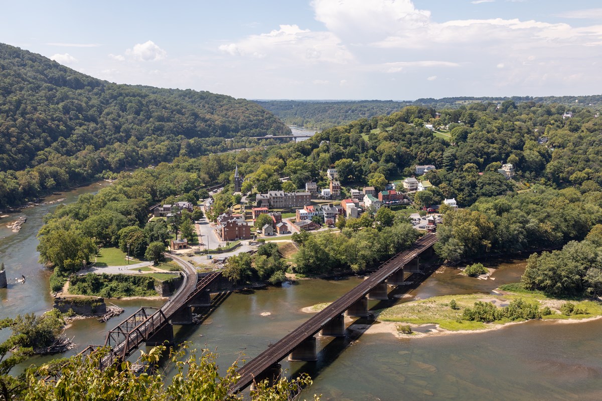
A big ridge hike, John Brown's Fort and the confluence of the Potomac and Shenandoah, with sunset at Jefferson Rock
- Length
- 1 day
- Total distance
- 165.6 mi
- Driving time
- 2 h 53 min
- Est. tolls
- $5.00
- Stops
- 5
- Driving
- Easy
- Best months
- Apr–May, Sep–Oct
- Budget
- $
A one-day, one-way drive from Philadelphia to Harpers Ferry, West Virginia: 165.6 miles and about 2 hours 53 minutes on I-95, I-70 and US-340, with one $5 Delaware toll. The day is spent on the Loudoun Heights climb, a late lunch in Lower Town, John Brown's Fort, The Point and a Jefferson Rock sunset.
- Drive time2 h 53 min
- Distance165.6 mi
- Est. tolls$5.00
- Loudoun Heights: a 1,377-foot climb on the Appalachian Trail to views of both rivers
- The Point: the confluence of the Potomac and Shenandoah, with John Brown's Fort a short walk away
- Jefferson Rock: Thomas Jefferson's 1783 view, timed for evening light
The story
Harpers Ferry sits where the Shenandoah meets the Potomac and the two rivers slice through the Blue Ridge together. From Philadelphia it is a 165.6-mile drive of about 2 hours 53 minutes by OSM routing, down I-95 and west on I-70, and the early start pays off in three ways: a better chance at one of the 36 spaces in the river-access lot, a full-daylight window for a long hike, and time left for the town before sunset.
The hike comes first, while legs are fresh. Loudoun Heights is the Virginia-side mountain, climbed on the Appalachian Trail from the Shenandoah River bridge: it is rated moderately strenuous, with about 1,377 feet of climbing and views of both rivers. Maryland Heights, the classic confluence overlook, waits in the options.
After the climb comes a late sandwich and coffee in Lower Town, then the old town itself. John Brown's Fort is the brick engine house where the 1859 raid ended, and The Point is where the rivers actually merge, with three states in view. The day closes at Jefferson Rock, a stack of slate on the Appalachian Trail where Thomas Jefferson stood in 1783 and wrote that the view was worth a voyage across the Atlantic. Be back down before the park's trails close at sunset.
Spring and fall are the favorite seasons: spring is rain and flowers and fall is chill and leaf change.
Day by day
Philadelphia to Harpers Ferry: the climb, the town and the sunset
Leave at 06:30, reach the Shenandoah Street river-access lot by about 09:25, and climb Loudoun Heights before the afternoon. Lunch, John Brown's Fort, The Point and Jefferson Rock at sunset fill the rest of the day.
Start in Philadelphia: 30th Street Station
Fuel up and set out from the 30th Street Station area by 06:30. The early start gets the car to Harpers Ferry around 09:25, in time to try for a space in the small river-access lot, to give a 4 to 5.5 hour hike full daylight, and to leave room for Lower Town and the evening light before sunset.

- Time
- 15 minutes to fuel up and go; Saturday departure assumed
Sources (2)
- 30th Street Station (address: 2955 Market Street) · retrieved 2026-10-08
- OpenStreetMap contributors (road network, routing via local OSRM) · retrieved 2026-10-08
Philadelphia to Harpers Ferry
- Distance
- 165.6 mi
- Drive time
- 2 h 53 min
- Est. tolls
- $5.00
- Via
- I-76, PA-291, I-95 (Delaware and Maryland), MD-43, I-695, I-70, US-15, US-340
South on I-76 and I-95 through Delaware and Maryland, around Baltimore on I-695, west on I-70, then US-15 and US-340 over the Potomac and Shenandoah into Harpers Ferry. There is no planned stop; if a break is needed, the Frederick, MD, exits (where the route leaves I-70, about 17 miles from the end) are the natural place, and a 10-15 minute break pushes arrival back by that long.
Tolls: Delaware's I-95 Newark Toll Plaza (Delaware Turnpike) lists $5.00 for a 2-axle car, cash or E-ZPass, in each direction. Maryland's I-95 JFK Memorial Highway toll (E-ZPass $6.00, video $12.00) is collected northbound only, so $0 southbound. No tolls on I-76, I-695, I-70, US-15 or US-340. As of 2026-10-08.
Sources (4)
- DelDOT: I-95 Newark Toll Plaza rates (2-axle car $5.00) · retrieved 2026-10-08
- Delaware DMV Toll Services: Newark Toll Plaza on I-95 · retrieved 2026-10-08
- MDTA: JFK Memorial Highway (I-95) rates, collected northbound only · retrieved 2026-10-08
- OpenStreetMap contributors (road network, routing via local OSRM) · retrieved 2026-10-08
Park at Shenandoah Street River Access
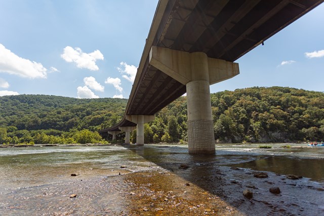
The lot sits where Shenandoah Street meets US-340, 0.5 to 0.75 miles from Lower Town and steps from the Loudoun Heights trailhead. It is first-come, first-served and often fills quickly. If it is full, use the Visitor Center lot at 171 Shoreline Drive and walk the Visitor Center to Lower Town Trail (1.6 miles one way), which passes this lot.
- Time
- 15 minutes to park, pay or show the entrance pass, and lace up; arrival about 09:23 by OSM, 2 minutes of slack
- Fee
- $20
- Parking
- First-come, first-served; the park shuttle does not stop here
- Fee note
- Per private vehicle, valid three consecutive days (fee record), as of 2026-10-08
Sources (3)
- NPS API: Harpers Ferry fees · retrieved 2026-10-08
- NPS: Harpers Ferry parking (River Access lot, Visitor Center lot) · retrieved 2026-10-08
- NPS: Shenandoah Street River Access · retrieved 2026-10-08
Loudoun Heights Trail to Split Rock Overlook
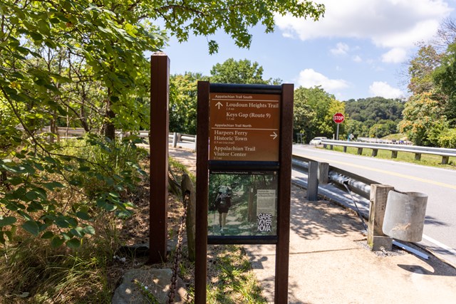
From the trailhead by the Shenandoah River bridge, take the staircase under the bridge and climb the Appalachian Trail (white blazes) up Loudoun Heights, the mountain with the steepest bluff above Harpers Ferry. A blue-blazed park trail leads to a first overlook; the full route follows a power-line cut to Split Rock Overlook, with views of both rivers. Turn around earlier if the clock demands it.
- Distance
- 7.5 mi
- Elevation gain
- 1,377 ft
- Route
- Out and back
- Difficulty
- Moderately strenuous (park rating); the hardest hike of this day
- Permit required
- No
- Trailhead
- Appalachian Trail beside the Shenandoah River bridge, Harpers Ferry
- Gain note
- 1,377 ft is the published elevation gain for the full route; AllTrails-type sites may differ.
- Distance note
- Round-trip, 'up to 7.5 miles' (4 to 5.5 hours). Segments: 1.3 mi on the AT to a blue-blazed junction, 0.4 mi to the first overlook, 0.25 mi to the crest, then 1.3 mi along the power-line cut to Split Rock Overlook. Turning around at the first overlook is roughly 3.4 mi round trip (1.3 + 0.4 each way, arithmetic from the segments).
Sources (4)
- NPS: Harpers Ferry hikes (Loudoun Heights 1,377 ft, moderately strenuous) · retrieved 2026-10-08
- NPS: Loudoun Heights Trail (distance, gain, route, 4-5.5 h) · retrieved 2026-10-08
- NPS: Loudoun Heights Trailhead · retrieved 2026-10-08
- NPS: Loudoun Heights (900-ft bluff, AT is the only hiking route to the ridge) · retrieved 2026-10-08
Late lunch at Battle Grounds Bakery & Coffee
A family-owned bakery and coffee shop on High Street in Lower Town, serving sandwiches, salads, pastries and coffee. Its official site lists 08:00 to 17:00 on Saturdays and Sundays (09:00 to 16:00 Monday to Friday), so a post-hike lunch works on any day of the plan. The walk in from the trailhead takes about 20 minutes.
- Meal
- Lunch
- Cuisine
- Bakery, sandwiches, coffee
- Reservation needed
- No
Sources (2)
- Battle Grounds Bakery & Coffee: hours and location (official) · retrieved 2026-10-08
- Battle Grounds Bakery & Coffee: menu (official) · retrieved 2026-10-08
John Brown's Fort
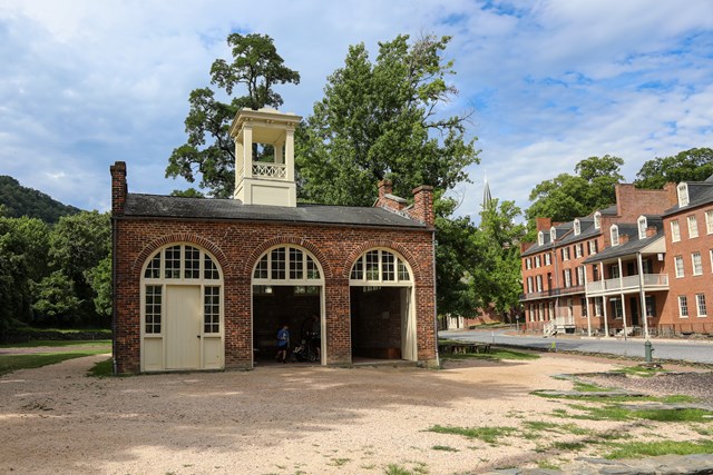
Built in 1848 as the armory's fire-engine and guard house, this small brick building is where John Brown and his raiders made their last stand in October 1859. It is the only armory building to survive the Civil War intact and has stood in five locations before the National Park Service moved it here in 1968. The path from the end of Shenandoah Street is loose gravel.
- Time
- Exterior and interior exhibit, 30-40 minutes
- Reservation needed
- No
Sources (2)
- NPS: Harpers Ferry current conditions (John Brown's Fort listed open) · retrieved 2026-10-08
- NPS: John Brown's Fort · retrieved 2026-10-08
The Point: where the Potomac meets the Shenandoah
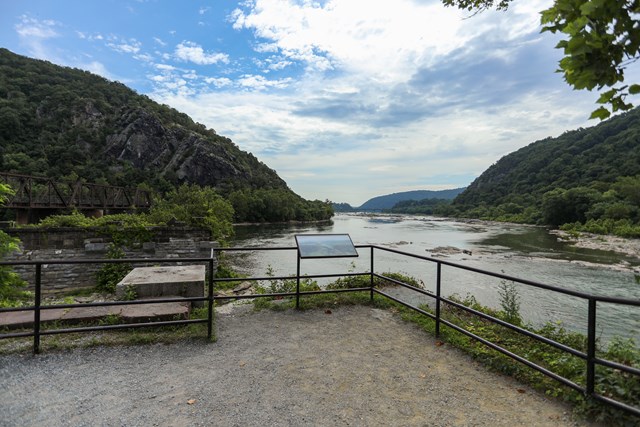
A gravel path of about 270 feet leads past John Brown's Fort and under the railroad tracks to the confluence itself. The view takes in three states, Maryland, Virginia and West Virginia, and the water gap the two rivers have cut through the Blue Ridge. The path climbs up to 11.5 percent in places.
- Time
- 20-30 minutes; slack after this stop absorbs a slow hike or time in Lower Town shops
- Best time
- Any daylight hour; the next stop is timed for the evening light
Sources (1)
- NPS: The Point, Harpers Ferry · retrieved 2026-10-08
Jefferson Rock at sunset
Climb the stone steps from High Street along the Appalachian Trail, past St. Peter's Catholic Church and the ruins of St. John Episcopal Church, to a slab of Harpers shale that Thomas Jefferson visited in 1783 and called a view worth a voyage across the Atlantic. The rock is unstable and off limits: view it from the designated area, and be back down by sunset.

- Time
- Climb 10-15 minutes, then 45-50 minutes of evening light; leave by 18:30 to be down before the 18:41 sunset on Oct 10
- Best time
- Late afternoon to sunset
- Reservation needed
- No
Sources (3)
- NPS: Jefferson Rock · retrieved 2026-10-08
- NPS: Step Back in Time at Jefferson Rock (1783 visit) · retrieved 2026-10-08
- NPS: Visit Jefferson Rock (route from High Street, off-limits notice) · retrieved 2026-10-08
More options
Maryland Heights Overlook (alternative to Loudoun Heights)
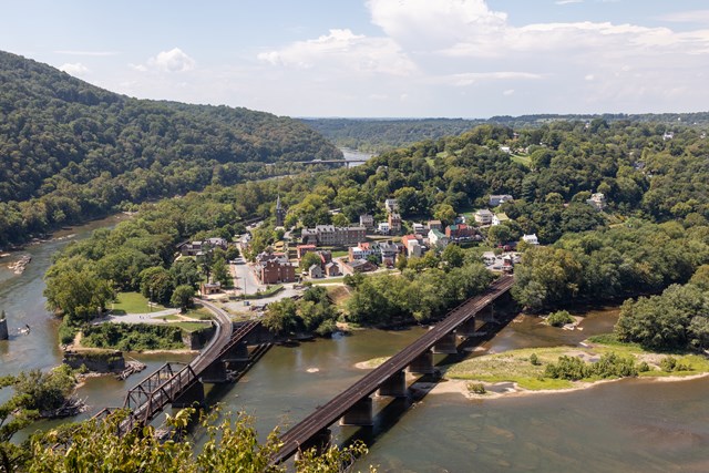
The classic confluence overlook: a climb to a cliff-edge view straight down on Harpers Ferry, both rivers and two railroad bridges, with Civil War fortification remnants on the way and an optional Stone Fort loop. It is the highest mountain overlooking Harpers Ferry. Do it instead of Loudoun Heights, not in addition. The normal access is the footbridge from Lower Town; read Current conditions first.
- Distance
- 4.5 mi
- Elevation gain
- 1,154 ft
- Route
- Out and back
- Difficulty
- Moderately strenuous to strenuous
- Trailhead
- C&O Canal towpath, reached by the Goodloe Byron Memorial Footbridge from Lower Town (or the Lock 34 shuttle)
- Gain note
- 1,154 ft is listed from Lower Town to the overlook, 1,522 ft for overlook plus Stone Fort, and 1,771 ft starting at the Visitor Center (the hikes summary gives a range of 990 to 1,788 ft); starting at Lock 34 instead of Lower Town changes the numbers slightly.
- Distance note
- Round trip. Overlook only 4.5 mi round trip; with the Stone Fort loop 6.5 mi round trip (3 to 4 hours).
Sources (3)
- NPS: Harpers Ferry hikes summary · retrieved 2026-10-08
- NPS: Maryland Heights Trail (distances, gains, access) · retrieved 2026-10-08
- NPS: Maryland Heights · retrieved 2026-10-08
Bolivar Heights walk (easy alternative)
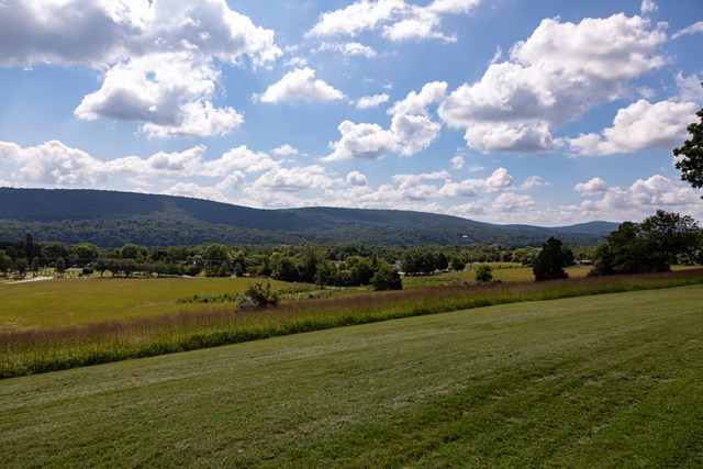
A gentler option on the open ridge west of Lower Town, where Union troops dug in before the September 1862 battle (interpretive panels). Routes run from a 0.3-mile stroll to a 2.4-mile loop with long Blue Ridge views, a good fit for tired legs or a shorter day.
- Distance
- 2.4 mi
- Elevation gain
- 263 ft
- Route
- Loop
- Difficulty
- Easy to moderate
- Trailhead
- Bolivar Heights parking area
- Gain note
- Elevation is listed as '4 to 263 feet' across the route options; 263 ft is used for the longest.
- Distance note
- Round trip; 0.3 to 2.4 mi round trip depending on the route (10 minutes to 1.6 hours).
Sources (2)
- NPS: Harpers Ferry hikes (Bolivar Heights 0.3-2.4 mi, 4-263 ft) · retrieved 2026-10-08
- NPS: Bolivar Heights · retrieved 2026-10-08
Scenic alternative: Lancaster County, Gettysburg country and Antietam
Skip the interstates: US-30 (Lincoln Highway) west across Lancaster County and past York, US-15 south, MD-77 over Catoctin Mountain, then MD-66 and MD-34 to Antietam National Battlefield, and MD-67 and US-340 to Harpers Ferry. Navigation apps prefer I-95. It adds about 25 miles and 90 minutes versus the default route, so it replaces the long hike with Antietam (Visitor Center, 5831 Dunker Church Rd, Sharpsburg) and a shorter Lower Town visit.
- Distance
- 191 mi
- Drive time
- 4 h 23 min
- Est. tolls
- No tolls
- Via
- I-76 (Schuylkill), US-202, US-30, PA-340/PA-772, US-15, MD-77, MD-66, MD-34, MD-67, US-340
- To
- Shenandoah Street River Access, Harpers Ferry
- From
- Philadelphia 30th Street Station
- Exclude
- toll
- Via points
- Lancaster, PA, York, PA, Antietam National Battlefield Visitor Center
Tolls: OSM toll-free routing (exclude=toll): US-30, US-15 and state routes, no PA Turnpike and no Delaware Turnpike plaza. Confirm no tolls before leaving. As of 2026-10-08.
Sources (4)
- NPS API: Antietam Visitor Center · retrieved 2026-10-08
- Maryland Route 77 (crosses Catoctin Mountain between Cunningham Falls State Park and Catoctin Mountain Park) · retrieved 2026-10-08
- NPS: Antietam National Battlefield directions (Visitor Center, 5831 Dunker Church Road) · retrieved 2026-10-08
- OpenStreetMap contributors (road network, routing via local OSRM) · retrieved 2026-10-08
Scenic alternative: South Mountain and Gathland State Park
Leave I-70 at Frederick for MD-17 through the Middletown Valley and over South Mountain to Gathland State Park (900 Arnoldstown Rd), home of a stone memorial arch to Civil War correspondents on the Appalachian Trail, then drop to US-340 for Harpers Ferry. MD-17 is part of the Journey Through Hallowed Ground and Antietam Campaign scenic byways. It adds about 7 miles and 20 minutes plus a 30-45 minute stop, which costs the Jefferson Rock sunset margin; Maryland DNR lists Gathland open from 10 a.m. October to March.
- Distance
- 172.4 mi
- Drive time
- 3 h 13 min
- Est. tolls
- $5.00
- Via
- I-76, I-95, I-695, I-70, MD-17, Gapland Rd, US-340
- To
- Shenandoah Street River Access, Harpers Ferry
- From
- Philadelphia 30th Street Station
- Via points
- Gathland State Park
Tolls: Same Delaware I-95 Newark Toll Plaza toll as the default route ($5.00, 2-axle car, DelDOT); Maryland JFK toll not collected southbound. As of 2026-10-08.
Sources (4)
- DelDOT: I-95 Newark Toll Plaza rates · retrieved 2026-10-08
- Maryland DNR: Gathland State Park (900 Arnoldstown Road, hours) · retrieved 2026-10-08
- Maryland Route 17 (scenic byway designations) · retrieved 2026-10-08
- OpenStreetMap contributors (road network, routing via local OSRM) · retrieved 2026-10-08
Route map
- Philadelphia 30th Street Station (opens Google Maps in a new tab) Day 1
- Shenandoah Street River Access (parking) (opens Google Maps in a new tab) Day 1
- Loudoun Heights Trailhead (opens Google Maps in a new tab) Day 1
- Battle Grounds Bakery & Coffee (opens Google Maps in a new tab) Day 1
- John Brown's Fort (opens Google Maps in a new tab) Day 1
- The Point, Harpers Ferry (opens Google Maps in a new tab) Day 1
- Jefferson Rock (opens Google Maps in a new tab) Day 1
- Maryland Heights (opens Google Maps in a new tab) Option
- Bolivar Heights (opens Google Maps in a new tab) Option
Good to know
Plan, timing and weekday
- Assumed weekday: Saturday departure (Saturday Oct 10, 2026 for the times shown). The bakery lunch is open on weekends (08:00-17:00) and weekdays (09:00-16:00), so any day works for the 14:45 lunch.
- Why 06:30: the Shenandoah Street river-access lot has 36 spaces and often fills quickly; a 4 to 5.5 hour hike needs daylight; John Brown's Fort and the park exhibits typically close at 17:00.
- Daylight on Oct 10: sunrise 07:14, sunset 18:41, civil twilight ends 19:06 (EDT, sunrise-sunset.org for Harpers Ferry). Park grounds and trails are open sunrise to sunset, so Jefferson Rock is timed to leave by 18:30.
- Slack: about 2 minutes on arrival, about 15 minutes after the hike (walk to town takes about 20), and about 50 minutes between The Point and Jefferson Rock for a slower hike (up to 5.5 hours), shops or the Industry Museum.
- Drive: 165.6 miles, 173 minutes, one $5 Delaware toll on a 2-axle car (DelDOT, Newark Toll Plaza); Maryland's I-95 toll is collected northbound only. The drive is highway driving (difficulty: easy). The way home is the same road, about three hours after dark; consider an overnight if that is too long.
- Hike notes: no water or restrooms on the Loudoun Heights trail; carry water and layers. Both Loudoun Heights and Maryland Heights trails are closed from sunset to sunrise.
- Season: best in spring and autumn; spring is rain and flowers and fall is the chill and leaf change. Leaf timing varies by year, so check a foliage report before picking the weekend.
Current conditions (as of 2026-10-08)
- Goodloe Byron Memorial Footbridge closed: Park alert (updated 2026-10-06): the footbridge to the C&O Canal towpath is expected to stay closed this fall for safety repairs, in addition to the staircase replacement. This affects Maryland Heights, the Appalachian Trail across the Potomac and the Potomac Heritage Trail, and the alert strongly advises other trails. This itinerary uses Loudoun Heights (Virginia side) so it does not depend on the bridge.
- Maryland Heights access now: the trail itself is open, but reaching it from Harpers Ferry means the free shuttle between the Visitor Center (171 Shoreline Drive) and C&O Canal Lock 34, about hourly, with very limited space, no pets and weather-dependent service. Shuttle hours are given as 9:00-18:30 by the Appalachian Trail Conservancy; the park's record gives the regular park shuttle as 9:00-17:30 and the Getting Around page as 9:00-19:00 during daylight saving time. Confirm before relying on a return shuttle.
- Exhibit spaces closed: Master Armorer's Quarters, Black Voices/African American History, Civil War Museum and Harper House; John Brown's Fort, the Industry Museum and the 1862 Battle of Harpers Ferry exhibit are listed open. The Lower Town Information Center is closed (maps at the 'Place in Time' exhibit or Visitor Center). A caution is also posted for repair work on Lower Town buildings. The southern loop of the Schoolhouse Ridge South trail is closed for sinkholes.
- Fees: $20 per private vehicle (valid three consecutive days), $10 per person on foot or bicycle, $35 annual park pass; the entrance station sells passes Thursday to Monday 9:00-16:00, and a Recreation.gov digital option is listed (recreation.gov/sitepass/2747). Park museums and Visitor Center 9:00-17:00; the park lists the shuttle as 9:00-17:30.
- C&O Canal NHP: a park alert (updated 2026-05-27) lists multiple towpath closures and detours; check the C&O Canal park website before planning any towpath walk.
- Tolls: Delaware I-95 Newark Toll Plaza rate effective since Aug 15, 2025 (DelDOT); confirm at deldot.gov.
Want live alerts and up-to-date info?
Roads, tolls and closures change fast. Create an account on the DriftKin app to get live alerts and up-to-date information for your drive.
Before you go
Hours, fees and trail status change; confirm with the official sources linked on each item.
Sources
Good to know: distances and drive times are typical figures without live traffic, and where routes are shown the route data comes from OpenStreetMap contributors. Toll amounts are estimates and change often, so check them in the DriftKin planner or with the toll authority before you plan around them. Opening hours, fees, prices, permits and closures also change, so confirm with the park or business before you go.
- 30th Street Station (address: 2955 Market Street) retrieved 2026-10-08
- OpenStreetMap contributors (road network, routing via local OSRM) retrieved 2026-10-08
- DelDOT: I-95 Newark Toll Plaza rates retrieved 2026-10-08
- Delaware DMV Toll Services: Newark Toll Plaza on I-95 retrieved 2026-10-08
- MDTA: JFK Memorial Highway (I-95) rates, collected northbound only retrieved 2026-10-08
- NPS API: Harpers Ferry fees retrieved 2026-10-08
- NPS: Harpers Ferry parking (River Access lot, Visitor Center lot) retrieved 2026-10-08
- NPS: Shenandoah Street River Access retrieved 2026-10-08
- NPS: Harpers Ferry hikes (Bolivar Heights 0.3-2.4 mi, 4-263 ft) retrieved 2026-10-08
- NPS: Loudoun Heights Trail (distance, gain, route, 4-5.5 h) retrieved 2026-10-08
- NPS: Loudoun Heights Trailhead retrieved 2026-10-08
- NPS: Loudoun Heights (900-ft bluff, AT is the only hiking route to the ridge) retrieved 2026-10-08
- Battle Grounds Bakery & Coffee: hours and location (official) retrieved 2026-10-08
- Battle Grounds Bakery & Coffee: menu (official) retrieved 2026-10-08
- NPS: Harpers Ferry current conditions (John Brown's Fort listed open) retrieved 2026-10-08
- NPS: John Brown's Fort retrieved 2026-10-08
- NPS: The Point, Harpers Ferry retrieved 2026-10-08
- NPS: Jefferson Rock retrieved 2026-10-08
- NPS: Step Back in Time at Jefferson Rock (1783 visit) retrieved 2026-10-08
- NPS: Visit Jefferson Rock (route from High Street, off-limits notice) retrieved 2026-10-08
- NPS: Maryland Heights Trail (distances, gains, access) retrieved 2026-10-08
- NPS: Maryland Heights retrieved 2026-10-08
- NPS: Bolivar Heights retrieved 2026-10-08
- NPS API: Antietam Visitor Center retrieved 2026-10-08
- Maryland Route 77 (crosses Catoctin Mountain between Cunningham Falls State Park and Catoctin Mountain Park) retrieved 2026-10-08
- NPS: Antietam National Battlefield directions (Visitor Center, 5831 Dunker Church Road) retrieved 2026-10-08
- Maryland DNR: Gathland State Park (900 Arnoldstown Road, hours) retrieved 2026-10-08
- Maryland Route 17 (scenic byway designations) retrieved 2026-10-08
More trips like this
 Road tripBoston to Portland via the White Mountains
Boston to Portland the Long Way: The Kancamagus and the White Mountains
1 day Easy$$ Road tripChicago to St. Louis (Route 66)
Chicago to St. Louis in One Day: Historic Route 66
1 day Easy$$ Road tripLas Vegas to Lone Pine
Las Vegas to Lone Pine in One Day: Through Death Valley to the Eastern Sierra
1 day Moderate$$