All trips
National park: Big Bend, TX

Big Bend: 2 Days of Chisos Ridges and a Desert Drive

One mountain hike, one scenic drive, and room to rest
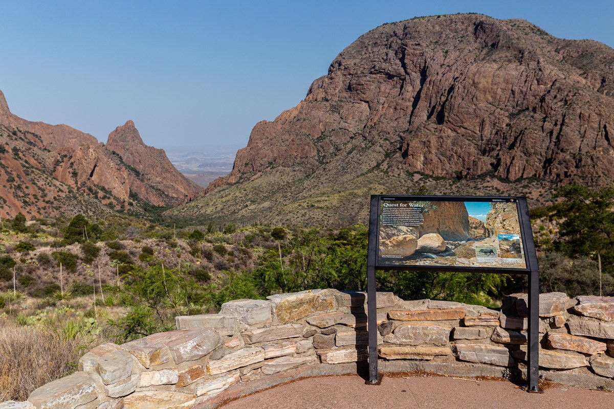
A paved trail and metal exhibit sign overlook a low basin surrounded by mountains.
Photo: NPS/CA Hoyt
Length
2 days
Difficulty
Moderate
Best months
Feb–Mar, Nov–Dec
Budget
$$

Two paced days in Big Bend National Park from a single base in the Chisos Basin: Lost Mine Trail and a Window sunset on day one, then the Ross Maxwell Scenic Drive to Castolon on day two.

  • Lost Mine Trail ridge views toward Mexico
  • Sunset through the Window from the Window View Trail
  • Sotol Vista and the Mule Ears on the Ross Maxwell Scenic Drive
  • Tuff Canyon and the historic adobes at Castolon

The story

Big Bend is a park you plan around distance. The Chisos Mountains rise in the middle of the Chihuahuan Desert, the Rio Grande makes its great bend along the southern edge, and everything is farther apart than the map suggests. This two-day plan gives each day one real idea and leaves room to breathe.

Day one lives in the Chisos Basin. Start early on Lost Mine Trail, the park's popular ridge walk with views toward Mexico, then spend the rest of the day easily: the visitor center, lunch, a long afternoon at the lodge, and sunset on the paved Window View Trail, where the desert glows through the notch in the mountains.

Day two is a drive, and a spectacular one. The Ross Maxwell Scenic Drive drops from the Basin to Sotol Vista, the Mule Ears, Tuff Canyon and the old adobe farming community of Castolon, with a picnic on the way and a relaxed return. No strenuous hike, just big desert scenery. When the road beyond Castolon is open, the Santa Elena Canyon Trail is the classic add-on.

Go between November and March, carry food and water, fuel up at Panther Junction, and book the lodge early; it is the only place to sleep in the park.

Day by day

Day 1 · 5 stops

Lost Mine Trail and a Window sunset

One morning ridge hike, then a deliberately easy afternoon in the Basin and sunset on a paved loop.

Must do
Hike7:30 AM · 3 h

Lost Mine Trail

The Basin's signature hike climbs steadily through juniper, oak and pine to a ridge with views over Juniper Canyon and Pine Canyon toward the Sierra del Carmen in Mexico. With limited time, the saddle about a mile in already delivers a wide view of Casa Grande. Distance and gain are for the full round trip. Start early: the small lot holds about 15 vehicles and typically fills between 8 and 9 am in the November to April busy season.

Photo: NPS/M. Schuler
Distance
4.8 mi
Elevation gain
1,100 ft
Route
Out and back
Difficulty
Moderate to strenuous
Dogs allowed
No
Trailhead
Lost Mine Trail parking lot on the Basin Road, about 1.3 miles from the lodge (about 4 minutes by road)
Lost Mine Trail
Basin Road, Panther Pass, Big Bend National Park, TX 79834
Season: Typically open year-round; check current conditions
Sources (1)
Visitor center11:00 AM · 45 min

Chisos Basin Visitor Center

A relaxed post-hike stop: interactive exhibits on Chisos plants, animals and birds, a bookstore, and rangers who can check road and trail conditions for tomorrow's drive. The center closes for lunch from noon to 1:00 pm, so go before 12.

Photo: NPS
Time
30-45 minutes
Chisos Basin Visitor Center
Chisos Basin Road, Big Bend National Park, TX 79834
Hours: Daily 8:30 am-4:00 pm, closed 12:00-1:00 pm (reduced hours Dec 25)
Sources (1)
Logistics12:00 PM · 45 min

Lunch in the Basin

Food is scarce in Big Bend: there is no grocery run on the way. Plan lunch from what you carried in or from the lodge-area concession services, and buy tomorrow's picnic lunch now, since Castolon has only packaged food. Fill water bottles; the Basin has potable water.

Meal
lunch
Sources (2)
Stay1:00 PM · 3 h

Chisos Mountains Lodge (your base for both nights)

The only lodging inside the park sits at 5,400 feet at the foot of Casa Grande, 10 miles from Panther Junction. Rest here through the warm afternoon; the Basin is 10-15 degrees cooler than the desert floor. It is often full, so book early; Terlingua-area stays in the options are about 45-60 minutes away. Check current rates when booking.

Photo: NPS
Type
Lodge
Location
Inside the park
Chisos Mountains Lodge
1 Basin Rural Station, Big Bend National Park, TX 79834
Season: Typically open year-round; check current dates
Sources (2)
Must do
Hike5:15 PM · 45 min

Window View Trail at sunset

A paved 0.3-mile loop behind the lodge with benches facing the V-shaped notch of the Window, where the desert glows at dusk. The grade is gentle (about 50 ft of change) and it is wheelchair accessible. Arrive 30 minutes before sunset; sunset time shifts a lot between November and March.

Photo: NPS/CA Hoyt
Distance
0.3 mi
Elevation gain
50 ft
Route
Loop
Difficulty
Easy
Dogs allowed
No
Window View Trail
Chisos Basin Road, near Chisos Mountains Lodge, Big Bend National Park, TX 79834
Sources (1)
Day 2 · 4 stops

Ross Maxwell Scenic Drive to Castolon

A scenic drive with short stops, a picnic at Castolon and an easy return, about 75 miles round trip.

Must do
Viewpoint9:00 AM · 20 min

Sotol Vista

The first big payoff on the Ross Maxwell Scenic Drive: a wide look over the park's west side, with Santa Elena Canyon as a tiny notch in the far mesa. A vault toilet here is welcome on a long drive. It is about 25 miles and 45 minutes from the lodge.

Photo: CA Hoyt
Time
15-20 minutes
Best time
Any time of day; especially nice at sunrise or sunset
Sotol Vista
Ross Maxwell Scenic Drive, Big Bend National Park, TX 79834
Season: Typically open year-round
Sources (1)
Must do
Viewpoint9:35 AM · 20 min

Mule Ears Overlook

A half-mile spur off the scenic drive leads to a paved overlook of the Mule Ears, twin eroded rhyolite peaks rising from the desert floor. The pull-in lot and sidewalk are accessible, and morning light is the traditional time to be here.

Photo: NPS/CA Hoyt
Time
15-20 minutes
Best time
Morning
Mule Ears Overlook
Mule Ears Overlook spur, Ross Maxwell Scenic Drive, Big Bend National Park, TX 79834
Sources (1)
Activity10:05 AM · 30 min

Tuff Canyon

A short walk of about half a mile round trip to three viewing platforms above a narrow canyon cut through welded gray volcanic tuff. Look for boulders and pebbles embedded in the walls. It is a quick, shaded-by-rock change of pace between overlooks.

Photo: NPS/B. Trester
Time
About 20-30 minutes; 0.5 mile round trip to three viewing platforms
Tuff Canyon
Ross Maxwell Scenic Drive, Big Bend National Park, TX 79834
Sources (1)
Must do
Activity10:45 AM · 1 h 45 min

Castolon Historic District and picnic lunch

Castolon is a cluster of adobe buildings from the border-farming and cavalry-camp era, with exhibits, a visitor center in the Garlick House in the cool season, and a small store with packaged food. There is no fuel here. Eat the lunch you packed in the shade, then drive back at a leisurely pace (about an hour to the lodge).

Photo: NPS/CA Hoyt
Time
About 1.5 hours with lunch; no fuel available
Castolon Historic District
Castolon, end of Ross Maxwell Scenic Drive, Big Bend National Park, TX 79834
Season: Typically visitor center open in the cool season; check current dates
Sources (2)

Where to stay

Stay

Chisos Basin Campground

Tent and small-RV sites in open woodland beside the same trailheads as the lodge, with views of Casa Grande and the Window. Reservations are required (none first-come); trailers over 20 feet and RVs over 24 feet are not recommended on the winding Basin road.

Stay

Chisos Basin Campground

Tent and small-RV sites in open woodland beside the same trailheads as the lodge, with views of Casa Grande and the Window. Reservations are required (none first-come); trailers over 20 feet and RVs over 24 feet are not recommended on the winding Basin road.

Photo: NPS
Type
Campground
Location
Inside the park
Price per night
From $16 (as of 2026-10-14)
Chisos Basin Campground
Chisos Basin Campground, Big Bend National Park, TX 79834
Sources (1)
Stay

La Posada Milagro Guesthouse (Terlingua)

Guest rooms and bunkrooms in Terlingua ghost town, about 30 miles from the Basin, the closest community lodging to the west-side drive. Its site lists the Espresso y Poco Mas cafe (7:30 am-2 pm daily) within a short walk. Check current rates and availability on its site.

Type
Hotel
Location
Outside the park
La Posada Milagro Guesthouse
45 Milagro Way, Terlingua, TX
Sources (1)
Stay

Terlingua Ranch Lodge

Cabin guest rooms, RV sites and campgrounds on a large ranch property north of the park, with a restaurant, pool and laundry listed on its site. It is a longer drive to the park (allow well over an hour to the Basin), so it suits travelers who want quiet and stars more than convenience.

Type
Lodge
Location
Outside the park
Terlingua Ranch Lodge
16000 Terlingua Ranch Rd, Terlingua, TX 79852
Sources (1)

More options

Hike

Santa Elena Canyon Trail (when the road is open)

The classic add-on at the far end of the scenic drive, 8 miles beyond Castolon: cross Terlingua Creek, climb steps to a high viewpoint, then follow the river to where the canyon wall meets the Rio Grande. Add about 21 minutes of driving each way and 1 to 1.5 hours on the trail. Creek conditions change, so ask a ranger before crossing.

Photo: NPS PHOTO/ Cathy Hoyt
Distance
1.6 mi
Elevation gain
80 ft
Route
Out and back
Difficulty
Moderate
Dogs allowed
No
Santa Elena Canyon Trail
End of Ross Maxwell Scenic Drive, Big Bend National Park, TX 79834
Sources (2)

Map of places

  1. Lost Mine Trail (opens Google Maps in a new tab) Day 1
  2. Chisos Basin Visitor Center (opens Google Maps in a new tab) Day 1
  3. Chisos Mountains Lodge (opens Google Maps in a new tab) Day 1
  4. Window View Trail (opens Google Maps in a new tab) Day 1
  5. Sotol Vista (opens Google Maps in a new tab) Day 2
  6. Mule Ears Overlook (opens Google Maps in a new tab) Day 2
  7. Tuff Canyon (opens Google Maps in a new tab) Day 2
  8. Castolon Historic District (opens Google Maps in a new tab) Day 2
  9. Santa Elena Canyon Trail (opens Google Maps in a new tab) Option
  10. Chisos Basin Campground (opens Google Maps in a new tab) Option
  11. La Posada Milagro Guesthouse (opens Google Maps in a new tab) Option
  12. Terlingua Ranch Lodge (opens Google Maps in a new tab) Option

Good to know

Current conditions (as of 2026-10-14)

  • Road closure: the paved road between Cottonwood Campground and Santa Elena Canyon is closed for weather-related reasons until further notice, so the Santa Elena Canyon Trail may not be reachable by car; the plan ends at Castolon. A Sept 25 news release said the Santa Elena Canyon Trail itself remained open during wildlife-management closures; confirm at a visitor center.
  • Chisos Mountains Lodge: the restaurant and gift shop are listed as closed and the front desk as closed (call 432-477-2291); a food truck outside the lodge is listed daily 8 am-8 pm (closed 10-11 am) and the Chisos Basin Store daily 8 am-10 pm.
  • Chisos Basin Visitor Center is open daily 8:30 am-4 pm (closed 12-1). Castolon Visitor Center is closed for the summer and typically open November to April, 10 am-4 pm; the Castolon Store is listed 9:30 am-5:30 pm (confirm days).
  • Entrance fee $30 per private vehicle for 7 days, card only. Cottonwood Campground reopens Nov 1.
  • Park alerts: no drones; pets are not allowed on trails.

Evergreen tips

  • Best months: November to March. Summer is extremely hot, with desert temperatures well above 100 F by late morning; the Basin is 10-15 degrees cooler. March is busiest.
  • Distances are long and services scarce: Panther Junction to Chisos Basin is about 10 miles, to Rio Grande Village about 20, and to Santa Elena Canyon about 35. Panther Junction has gas and diesel (24/7 pumps with card); there is no fuel at Castolon or the Basin. Fill up and bring food and water.
  • Wildlife can cross park roads at dusk; plan to be off the long drives by late afternoon.
  • Cell service is limited; download offline maps.
  • Dirt roads such as Old Ore Road need high-clearance 4x4; this plan stays on pavement.

Want live alerts and up-to-date info?

Conditions change fast. Create an account on the DriftKin app to get live park alerts, closures and information for your trip.

Get the DriftKin app

Sources

Good to know: distances and drive times are typical figures without live traffic, and where routes are shown the route data comes from OpenStreetMap contributors. Toll amounts are estimates and change often, so check them in the DriftKin planner or with the toll authority before you plan around them. Opening hours, fees, prices, permits and closures also change, so confirm with the park or business before you go.